IMAGES TAKEN NEAR TO
Clarkes Lane, ROCHDALE, OL12 6PY
Introduction
This page details the photographs taken nearby to Clarkes Lane, OL12 6PY by members of the Geograph project.
The Geograph project started in 2005 with the aim of publishing, organising and preserving representative images for every square kilometre of Great Britain, Ireland and the Isle of Man.

There are currently over 7.5m images from over14,400 individuals and you can help contribute to the project by visiting https://www.geograph.org.uk
Image Map
Images are licensed for reuse under creativecommons.org/licenses/by-sa/2.0
Notes
- Clicking on the map will re-center to the selected point.
- The higher the marker number, the further away the image location is from the centre of the postcode.
Image Listing (9 Images Found)
Images are licensed for reuse under creativecommons.org/licenses/by-sa/2.0
Image
Details
Distance
1
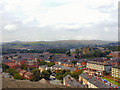
St Clement's and beyond!
This was taken from the top floor of one of the Seven Sisters (College Bank Flats). Middle right is St Clement's Church and in the distance to the left is Knowle Hill (they want to build a wind farm here). In the distance centre you can just make out the track going over Rooley Moor towards Bacup.
Image: © Jeff Mills
Taken: 22 Aug 2001
0.07 miles
2
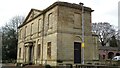
Falinge Hall Facade
The remains of an 18th century hall now in a public park
Image: © Kevin Waterhouse
Taken: 21 Mar 2018
0.18 miles
3
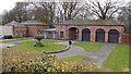
Stable Court
The former stables to Falinge Hall now in a public park
Image: © Kevin Waterhouse
Taken: 21 Mar 2018
0.18 miles
4
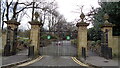
Falinge Park Gates
The southern entrance at the junction of Falinge Road and Sheriff Street
Image: © Kevin Waterhouse
Taken: 23 Mar 2018
0.18 miles

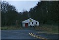
6
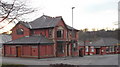
"Spotland Bridge Funeral Services" 225 Spotland Road, Rochdale
Was a pub
Image: © Robert Wade
Taken: 29 Jan 2011
0.22 miles
7
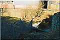
Weir on River Spodden, Rochdale
At the west end of Holmes Street. On the far side of the Spodden here was the electric tram depot of Rochdale Corporation, newly built for when electric cars replaced the former steam cars. Later it was a bus depot and survived into the PTE era, but has now been demolished and the site has other commercial uses.
Image: © Dr Neil Clifton
Taken: 28 Jan 2003
0.23 miles
8
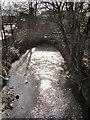
River Spodden
Downstream from Spotland Bridge
Image: © David Dixon
Taken: 1 Mar 2010
0.24 miles