IMAGES TAKEN NEAR TO
Healey Avenue, ROCHDALE, OL12 6EG
Introduction
This page details the photographs taken nearby to Healey Avenue, OL12 6EG by members of the Geograph project.
The Geograph project started in 2005 with the aim of publishing, organising and preserving representative images for every square kilometre of Great Britain, Ireland and the Isle of Man.

There are currently over 7.5m images from over14,400 individuals and you can help contribute to the project by visiting https://www.geograph.org.uk
Image Map
Images are licensed for reuse under creativecommons.org/licenses/by-sa/2.0
Notes
- Clicking on the map will re-center to the selected point.
- The higher the marker number, the further away the image location is from the centre of the postcode.
Image Listing (18 Images Found)
Images are licensed for reuse under creativecommons.org/licenses/by-sa/2.0
Image
Details
Distance
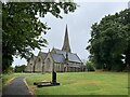
5
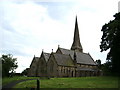
Christ Church
Christ Church Healey is a Grade II listed building.It was consecrated on the 16th October 1850 boasts a delightful peal of 6 bells.
Image: © Robert Bond
Taken: 11 Mar 2009
0.05 miles
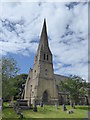
6
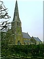
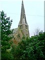
Christ Church
Christ Church is a Grade II listed building. It was consecrated on the 16th October 1850 and boasts a delightful peal of 6 bells.
Image: © Robert Bond
Taken: 11 Mar 2009
0.05 miles
7
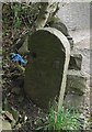
Old Boundary Marker by the A671, Market Street, Rochdale Parish
Municipal Boundary Marker in parish of Rochdale (Rochdale District), Middle Healey, On North side of A671.
Surveyed
Milestone Society National ID: LA_ROCH06pb
Image: © Milestone Society
Taken: Unknown
0.12 miles
8
Gandy Brow
Parked in lay-by on the A671 then easily found the path to the summit near the wall and tree stump.
Name: Gandy Brow
Hill number: 18898
Height: 238m / 781ft
Parent (Ma/M): 2820 Freeholds Top
Area: 36: Lancashire, Cheshire & the Southern Pennines
Class: 2
Grid ref: SD 88300 15800 (est)
Drop: 30m
Col: 208m SD884159
Image: © Rude Health
Taken: 10 Jul 2014
0.12 miles
9
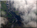
Whitworth Road from the air
The A671 is named Market Street in the lower half of the photo, becoming Whitworth Road as it heads towards the centre of Rochdale.
Image: © Thomas Nugent
Taken: 19 Oct 2018
0.13 miles