IMAGES TAKEN NEAR TO
Foxholes Road, ROCHDALE, OL12 0ET
Introduction
This page details the photographs taken nearby to Foxholes Road, OL12 0ET by members of the Geograph project.
The Geograph project started in 2005 with the aim of publishing, organising and preserving representative images for every square kilometre of Great Britain, Ireland and the Isle of Man.

There are currently over 7.5m images from over14,400 individuals and you can help contribute to the project by visiting https://www.geograph.org.uk
Image Map (Loading...)


Getting Data...Please wait
Leaflet Map data © OpenStreetMap
Images are licensed for reuse under creativecommons.org/licenses/by-sa/2.0
Notes
- Clicking on the map will re-center to the selected point.
- The higher the marker number, the further away the image location is from the centre of the postcode.
Image Listing (43 Images Found)
Images are licensed for reuse under creativecommons.org/licenses/by-sa/2.0
Image
Details
Distance
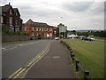
1
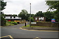
Foxholes House
Rochdale Council building which they are trying to get rid of under the current austerity measures.
Image: © Bill Boaden
Taken: 20 Jul 2012
0.03 miles
5
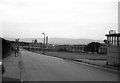
Cronkeyshaw Common, Rochdale, Lancashire
Cronkeyshaw Common is a L-shaped strip of grassed land, about 100m wide by 2 km long in total. This picture is looking along Fieldhouse Road to the east. John Bright's Fieldhouse Mills are out of picture to the left, behind the lady who waits for a No 10 bus destined for Syke terminus. Along the Common, a line of vertical flagstones marks the cutting where the ex-L.Y.R. Rochdale to Facit line runs across, (this cutting was later filled in). In the distance is the Eclipse Mill with its stack, and on the far side of the common, the terrace houses of Greenbank Road are seen. Cronkeyshaw Common is the only place where I have ever seen a notice specifically prohibiting the playing of golf.
Image: © Dr Neil Clifton
Taken: 2 Aug 1968
0.15 miles
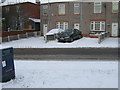
7
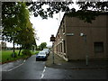
Blanche Street
Residential street with Brown Wardle in the far distance.
Image: © Bill Boaden
Taken: 20 Jul 2012
0.17 miles
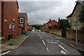
8
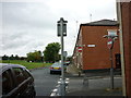
Fieldhouse Road, Rochdale
Looking east from the junction with the A671, Whitworth Road. Cronkeyshaw Common can be seen right of shot.
Image: © michael ely
Taken: 25 Jun 2010
0.18 miles
10
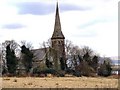
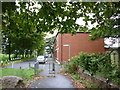
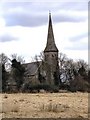
Church of All Saints, Hamer
Foxholes Road
Image: © David Dixon
Taken: 16 Mar 2010
0.18 miles