IMAGES TAKEN NEAR TO
Jermyn Street, ROCHDALE, OL12 0DP
Introduction
This page details the photographs taken nearby to Jermyn Street, OL12 0DP by members of the Geograph project.
The Geograph project started in 2005 with the aim of publishing, organising and preserving representative images for every square kilometre of Great Britain, Ireland and the Isle of Man.

There are currently over 7.5m images from over14,400 individuals and you can help contribute to the project by visiting https://www.geograph.org.uk
Image Map (Loading...)


Getting Data...Please wait
Leaflet Map data © OpenStreetMap
Images are licensed for reuse under creativecommons.org/licenses/by-sa/2.0
Notes
- Clicking on the map will re-center to the selected point.
- The higher the marker number, the further away the image location is from the centre of the postcode.
Image Listing (29 Images Found)
Images are licensed for reuse under creativecommons.org/licenses/by-sa/2.0
Image
Details
Distance
1
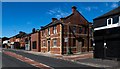
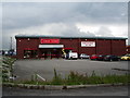
Building
Newly refurbished building.
Image: © Peter McDermott
Taken: 25 May 2020
0.04 miles
2
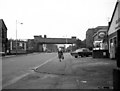
Wardleworth Railway Station (Site of): 2007
The location of Wardleworth Railway Station which stood on the Rochdale to Bacup line (Closed in 1947)
Image: © Paul Hogg
Taken: 24 Nov 2007
0.08 miles
3
Wardleworth Bridge, Rochdale, Lancashire, from the east
This was the railway bridge carrying the ex-L.Y.R. Rochdale to Facit branch, which spanned the upper part of Yorkshire Street. Seen here from the east, this bridge was later removed after the branch line had become completely disused. On each of the abutments can be discerned a coat of arms, which was that of the Lancashire and Yorkshire Railway.
Image: © Dr Neil Clifton
Taken: 19 Aug 1970
0.11 miles
4
Wardleworth Bridge, Yorkshire Street, Rochdale, Lancashire
This was the railway bridge carrying the ex-L.Y.R. Rochdale to Facit branch, which spanned the upper part of Yorkshire Street. Seen here from the west, this bridge was later removed, as the branch line had become completely disused. On the left hand abutment can just be discerned a coat of arms, which was that of the Lancashire and Yorkshire Railway.
Image: © Dr Neil Clifton
Taken: 19 Aug 1970
0.14 miles
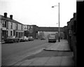
6
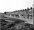
Backs of houses on Oswald Street, Rochdale, Lancashire
The waste ground in the foreground of this photograph is the site of a high railway embankment carrying the L&Y Rochdale to Bacup line. The embankment was removed after the line had closed, shortly before this was taken
Image: © Dr Neil Clifton
Taken: 15 Sep 1979
0.19 miles
7
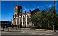
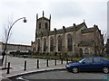
St Mary's Church
St Mary's Ukrainian Roman Catholic Church in Rochdale.
Image: © Peter McDermott
Taken: 25 May 2020
0.19 miles
8
St Mary Ukrainian RC Church, Rochdale
Image: © Alexander P Kapp
Taken: 25 Jan 2010
0.19 miles
9
St Mary Ukrainian RC Church, Rochdale
Image: © Alexander P Kapp
Taken: 25 Jan 2010
0.19 miles
10
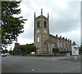
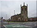
Ukrainian Catholic Church of Saint Mary
The Grade II listed https://historicengland.org.uk/listing/the-list/list-entry/1346258?section=official-list-entry church dates from 1821 and was formerly the Anglican Church of St James. It became a Ukrainian Catholic Church in 1975.
Image: © Gerald England
Taken: 6 Aug 2022
0.20 miles