IMAGES TAKEN NEAR TO
Somerset Grove, ROCHDALE, OL11 5YS
Introduction
This page details the photographs taken nearby to Somerset Grove, OL11 5YS by members of the Geograph project.
The Geograph project started in 2005 with the aim of publishing, organising and preserving representative images for every square kilometre of Great Britain, Ireland and the Isle of Man.

There are currently over 7.5m images from over14,400 individuals and you can help contribute to the project by visiting https://www.geograph.org.uk
Image Map
Images are licensed for reuse under creativecommons.org/licenses/by-sa/2.0
Notes
- Clicking on the map will re-center to the selected point.
- The higher the marker number, the further away the image location is from the centre of the postcode.
Image Listing (20 Images Found)
Images are licensed for reuse under creativecommons.org/licenses/by-sa/2.0
Image
Details
Distance
3
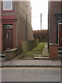
Sandstone slab wall
The dividing feature between Nos 347 and 349 Edenfield Road
Image: © Alexander P Kapp
Taken: 13 Feb 2009
0.08 miles
4
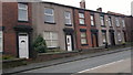
339 to 357 Edenfield Road, Rochdale
House numbers 339 to 357 Edenfield Road in the Cutgate area of Rochdale, Greater Manchester. Such red-brick terraced houses are typical of much of Rochdale and of Greater Manchester.
Image: © Steven Haslington
Taken: 18 Nov 2011
0.10 miles
7
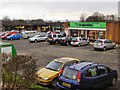
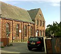
Cutgate Shopping Precinct
Taken from the pedestrian access at the northern end of the precinct.
Image: © David Dixon
Taken: 20 Jan 2010
0.10 miles
8
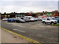
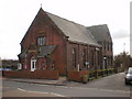
Cutcate Shopping Precinct
Taken from the vehicular access toand from Edenfield Road.
Image: © David Dixon
Taken: 20 Jan 2010
0.10 miles