IMAGES TAKEN NEAR TO
Moor Hill, ROCHDALE, OL11 5YB
Introduction
This page details the photographs taken nearby to Moor Hill, OL11 5YB by members of the Geograph project.
The Geograph project started in 2005 with the aim of publishing, organising and preserving representative images for every square kilometre of Great Britain, Ireland and the Isle of Man.

There are currently over 7.5m images from over14,400 individuals and you can help contribute to the project by visiting https://www.geograph.org.uk
Image Map
Images are licensed for reuse under creativecommons.org/licenses/by-sa/2.0
Notes
- Clicking on the map will re-center to the selected point.
- The higher the marker number, the further away the image location is from the centre of the postcode.
Image Listing (38 Images Found)
Images are licensed for reuse under creativecommons.org/licenses/by-sa/2.0
Image
Details
Distance
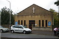
1
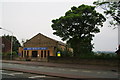
Norden Methodist Church
On Edenfield Road.
Image: © Bill Boaden
Taken: 26 Jul 2012
0.11 miles
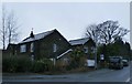
5
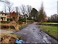
St George's Road
Quiet road behind the golf course.
Image: © David Dixon
Taken: 21 Jan 2010
0.13 miles
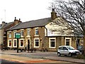
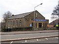
9
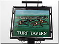
The Turf Tavern, Norden
A Sam Smiths public house.
Image: © Ian S
Taken: 10 Jul 2012
0.13 miles
10
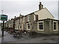
The Turf Tavern, Norden
A Sam Smiths public house.
Image: © Ian S
Taken: 10 Jul 2012
0.13 miles