IMAGES TAKEN NEAR TO
Rushlake Gardens, ROCHDALE, OL11 5WH
Introduction
This page details the photographs taken nearby to Rushlake Gardens, OL11 5WH by members of the Geograph project.
The Geograph project started in 2005 with the aim of publishing, organising and preserving representative images for every square kilometre of Great Britain, Ireland and the Isle of Man.

There are currently over 7.5m images from over14,400 individuals and you can help contribute to the project by visiting https://www.geograph.org.uk
Image Map
Images are licensed for reuse under creativecommons.org/licenses/by-sa/2.0
Notes
- Clicking on the map will re-center to the selected point.
- The higher the marker number, the further away the image location is from the centre of the postcode.
Image Listing (9 Images Found)
Images are licensed for reuse under creativecommons.org/licenses/by-sa/2.0
Image
Details
Distance
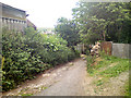
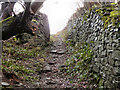
4
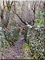
Path from Whittaker Moss to Norden Village
Looking down the hill towards Norden, along the path from behind Whittaker Moss School. The spire of Image] can be seen in the distance.
Image: © David Dixon
Taken: 5 Jan 2011
0.23 miles
5
Path from Whittaker Moss to Norden Village
Image: © David Dixon
Taken: 5 Jan 2011
0.24 miles
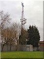
6
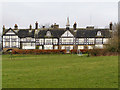
Scott House
Scott House hospital, Furbarn Road.Part of the Calderstones Partnership NHS Foundation Trust.
Image: © David Dixon
Taken: 26 Jan 2010
0.24 miles
7
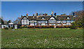
Scott House
An NHS care home in Norden.
Image: © Peter McDermott
Taken: 18 Apr 2014
0.25 miles
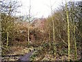
8
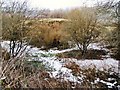
Whittaker Moss
Land between Highwood and Norden Village.
Image: © David Dixon
Taken: 21 Jan 2010
0.25 miles
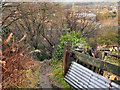
9
Path from Whittaker Moss to Norden Village
Looking back up the hill towards the Whittaker Moss estate.
Image: © David Dixon
Taken: 5 Jan 2011
0.25 miles