IMAGES TAKEN NEAR TO
Ashworth Road, ROCHDALE, OL11 5UN
Introduction
This page details the photographs taken nearby to Ashworth Road, OL11 5UN by members of the Geograph project.
The Geograph project started in 2005 with the aim of publishing, organising and preserving representative images for every square kilometre of Great Britain, Ireland and the Isle of Man.

There are currently over 7.5m images from over14,400 individuals and you can help contribute to the project by visiting https://www.geograph.org.uk
Image Map
Images are licensed for reuse under creativecommons.org/licenses/by-sa/2.0
Notes
- Clicking on the map will re-center to the selected point.
- The higher the marker number, the further away the image location is from the centre of the postcode.
Image Listing (8 Images Found)
Images are licensed for reuse under creativecommons.org/licenses/by-sa/2.0
Image
Details
Distance
2
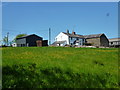
Copped Hill Farm, Ashworth Valley, Rochdale
The farm is at the end of the concrete farm road. No farm is shown here on the 1940s OS map. View NE towards Knowl Moor.
Image: © michael ely
Taken: 8 Dec 2005
0.07 miles
3
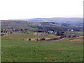
Copped Hill, Ashworth, Lancashire
View of Copped Hill looking east towards Rochdale.
Image: © ethics girl
Taken: 3 Mar 2008
0.08 miles
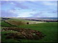
4
Ashworth Moor
Looking across Ashworth Moor, towards Knowl Hill.
Image: © David Dixon
Taken: 25 Mar 2010
0.08 miles

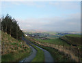
6
Ashworth Moor
Looking across Ashworth Moor towards Norden, from Ashworth Road.
Image: © David Dixon
Taken: 25 Mar 2010
0.17 miles
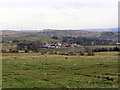
7
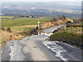
Copped Hill
Looking down into Ashworth Valley, towards Heywood.
Image: © David Dixon
Taken: 25 Mar 2010
0.17 miles
8
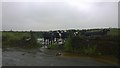
Cows and gate
Cows stand at a gate along Ashworth Road on the outskirts of Rochdale and Heywood, in Greater Manchester, England.
Image: © Steven Haslington
Taken: 15 Jun 2014
0.18 miles