IMAGES TAKEN NEAR TO
Fulmar Gardens, ROCHDALE, OL11 5RB
Introduction
This page details the photographs taken nearby to Fulmar Gardens, OL11 5RB by members of the Geograph project.
The Geograph project started in 2005 with the aim of publishing, organising and preserving representative images for every square kilometre of Great Britain, Ireland and the Isle of Man.

There are currently over 7.5m images from over14,400 individuals and you can help contribute to the project by visiting https://www.geograph.org.uk
Image Map
Images are licensed for reuse under creativecommons.org/licenses/by-sa/2.0
Notes
- Clicking on the map will re-center to the selected point.
- The higher the marker number, the further away the image location is from the centre of the postcode.
Image Listing (6 Images Found)
Images are licensed for reuse under creativecommons.org/licenses/by-sa/2.0
Image
Details
Distance
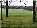
1
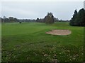
Rochdale Golf Course
Receiving some greensman attention viewed from a path off Bagslate Moor Road
Image: © Kevin Waterhouse
Taken: 1 Dec 2022
0.17 miles
2
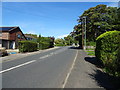
Martlet Avenue, Bamford
This road runs through an estate where all the streets are named after birds. The shot is taken from Curlew Close.
Image: © Bill Boaden
Taken: 22 Sep 2010
0.18 miles
3
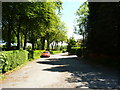
Bamford: Taylor Avenue
Bamford is generally regarded as one of the most desirable residence areas in Rochdale. On Taylor Avenue, shown here, there are only houses on the south (right-hand) side, all owner-occupied.
Image: © Dr Neil Clifton
Taken: 4 Jun 2013
0.18 miles
4
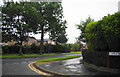
Rochdale Golf Course
From Bagslate Moor Road
Image: © David Dixon
Taken: 21 Jan 2010
0.23 miles
5
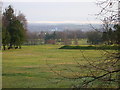
Rochdale Golf Course looking East towards the Pennine Hills beyond Rochdale town
Image: © Peter Messum
Taken: 23 Nov 2003
0.23 miles