IMAGES TAKEN NEAR TO
Canterbury Close, ROCHDALE, OL11 5LZ
Introduction
This page details the photographs taken nearby to Canterbury Close, OL11 5LZ by members of the Geograph project.
The Geograph project started in 2005 with the aim of publishing, organising and preserving representative images for every square kilometre of Great Britain, Ireland and the Isle of Man.

There are currently over 7.5m images from over14,400 individuals and you can help contribute to the project by visiting https://www.geograph.org.uk
Image Map
Images are licensed for reuse under creativecommons.org/licenses/by-sa/2.0
Notes
- Clicking on the map will re-center to the selected point.
- The higher the marker number, the further away the image location is from the centre of the postcode.
Image Listing (7 Images Found)
Images are licensed for reuse under creativecommons.org/licenses/by-sa/2.0
Image
Details
Distance
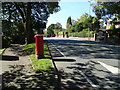
1

Elizabeth II postbox on Bury Road, Rochdale
Postbox No. OL11 120.
See Image] for context.
Image: © JThomas
Taken: 25 Sep 2018
0.16 miles
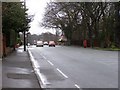
2
Bury Road, Rochdale (B6222)
Showing position of Postbox No. OL11 120.
See Image] for postbox.
Image: © JThomas
Taken: 25 Sep 2018
0.16 miles
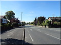
3
Bury Road
Bury Road, Rochdale; looking in the direction of Rochdale.
Image: © David Dixon
Taken: 2 Feb 2010
0.16 miles
4
Bury Road, Rochdale
Looking south west on the B6222.
Image: © JThomas
Taken: 25 Sep 2018
0.19 miles
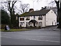
6
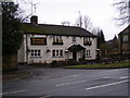
Elephant and Castle
Bury Road, Rochdale.
Image: © David Dixon
Taken: 2 Feb 2010
0.22 miles
7
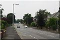
Bury Road, Bamford
Most of Bamford is residential like this, with larger than average houses.
Image: © Bill Boaden
Taken: 26 Jul 2012
0.22 miles