IMAGES TAKEN NEAR TO
Marne Crescent, ROCHDALE, OL11 5DN
Introduction
This page details the photographs taken nearby to Marne Crescent, OL11 5DN by members of the Geograph project.
The Geograph project started in 2005 with the aim of publishing, organising and preserving representative images for every square kilometre of Great Britain, Ireland and the Isle of Man.

There are currently over 7.5m images from over14,400 individuals and you can help contribute to the project by visiting https://www.geograph.org.uk
Image Map
Images are licensed for reuse under creativecommons.org/licenses/by-sa/2.0
Notes
- Clicking on the map will re-center to the selected point.
- The higher the marker number, the further away the image location is from the centre of the postcode.
Image Listing (33 Images Found)
Images are licensed for reuse under creativecommons.org/licenses/by-sa/2.0
Image
Details
Distance
1
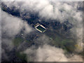
Spotland Stadium from the air
Home of Rochdale A.F.C. and Rochdale Hornets R.F.L.C. Has a capacity of 10,249.
See also Image & Image
Image: © Thomas Nugent
Taken: 19 Oct 2018
0.10 miles
2
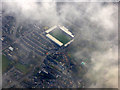
Spotland Stadium from the air
Home of Rochdale A.F.C. and Rochdale Hornets R.F.L.C. Has a capacity of 10,249.
See also Image & Image
Image: © Thomas Nugent
Taken: 19 Oct 2018
0.10 miles
3
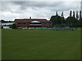
Rochdale Cricket Club - Pavilion
Rochdale Cricket Club play in the Central Lancashire League.
Their full title is Rochdale Cricket, Squash & Lacrosse Club. They moved from their Dane Street ground in the 1990's to the site of the old Redbrook Middle School. An ASDA store now stands on the old ground.
Image: © BatAndBall
Taken: 16 Jun 2011
0.17 miles
5
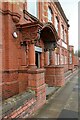
Former Rochdale Corporation tramway offices, Mellor Street ? 1
The main entrance, showing some very florid decorative terracotta. See https://www.geograph.org.uk/photo/7147788
Image: © Alan Murray-Rust
Taken: 8 Apr 2022
0.19 miles
6
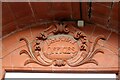
Former Rochdale Corporation tramway offices, Mellor Street ? 2
Terracotta plaque above the entrance door. See https://www.geograph.org.uk/photo/7147788 for location.
Image: © Alan Murray-Rust
Taken: 8 Apr 2022
0.19 miles
7
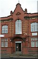
Former Rochdale Corporation tramway offices, Mellor Street ? 3
Central bay with entrance doorway and dated gable. See https://www.geograph.org.uk/photo/7147788 for location.
Image: © Alan Murray-Rust
Taken: 8 Apr 2022
0.19 miles
8
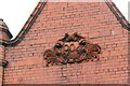
Former Rochdale Corporation tramway offices, Mellor Street ? 4
Terracotta date plaque. See https://www.geograph.org.uk/photo/7147788 for location.
Image: © Alan Murray-Rust
Taken: 8 Apr 2022
0.19 miles
9
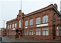
Former Rochdale Corporation tramway offices, Mellor Street ? 5
The main part of the offices, fronting Mellor Street. Built in 1904 soon after the local steam tramways had been taken over and electrified by the Corporation. The Corporation Transport was taken over in 1969 by Selnec which then became Greater Manchester Transport. In 1986 it was privatised as GM Buses. The Rochdale garage was closed in 1991 as a cost saving exercise and now houses a variety of businesses.
Image: © Alan Murray-Rust
Taken: 8 Apr 2022
0.19 miles
10
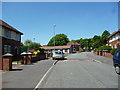
Greave: Denehurst Road
It will be seen that there appears to be one pair of semis missing from the left hand side of Denehurst Road on this picture. These were numbers 25 and 27, which were demolished about twenty years ago, as they were structurally unsound. The Greave estate was built immediately after World War II by Rochdale Corporation.
Image: © Dr Neil Clifton
Taken: 4 Jun 2013
0.19 miles