IMAGES TAKEN NEAR TO
Marland Fold, ROCHDALE, OL11 4RF
Introduction
This page details the photographs taken nearby to Marland Fold, OL11 4RF by members of the Geograph project.
The Geograph project started in 2005 with the aim of publishing, organising and preserving representative images for every square kilometre of Great Britain, Ireland and the Isle of Man.

There are currently over 7.5m images from over14,400 individuals and you can help contribute to the project by visiting https://www.geograph.org.uk
Image Map
Images are licensed for reuse under creativecommons.org/licenses/by-sa/2.0
Notes
- Clicking on the map will re-center to the selected point.
- The higher the marker number, the further away the image location is from the centre of the postcode.
Image Listing (24 Images Found)
Images are licensed for reuse under creativecommons.org/licenses/by-sa/2.0
Image
Details
Distance
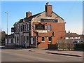
7
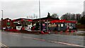
Marland Service Station, Bolton Road, Rochdale
Bolton Road is part of the A58 running between Prescot, Merseyside and Wetherby, West Yorkshire.
Image: © Stephen Armstrong
Taken: 13 Feb 2022
0.19 miles