IMAGES TAKEN NEAR TO
Kemp Avenue, ROCHDALE, OL11 4LR
Introduction
This page details the photographs taken nearby to Kemp Avenue, OL11 4LR by members of the Geograph project.
The Geograph project started in 2005 with the aim of publishing, organising and preserving representative images for every square kilometre of Great Britain, Ireland and the Isle of Man.

There are currently over 7.5m images from over14,400 individuals and you can help contribute to the project by visiting https://www.geograph.org.uk
Image Map
Images are licensed for reuse under creativecommons.org/licenses/by-sa/2.0
Notes
- Clicking on the map will re-center to the selected point.
- The higher the marker number, the further away the image location is from the centre of the postcode.
Image Listing (17 Images Found)
Images are licensed for reuse under creativecommons.org/licenses/by-sa/2.0
Image
Details
Distance
1
Manchester Road, Sudden
The original course of the road is in the background, superseded by the much wider highway now in use.
Image: © Peter Whatley
Taken: 25 Mar 2011
0.08 miles
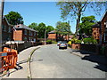
2
Manchester Road (old), Rochdale
Looking south-westward. I have added 'old' to the title as a modern dual carriage way road (A58) to the left of the picture is also called Manchester Road.
Image: © Peter Wood
Taken: 7 Feb 2023
0.09 miles
7
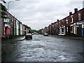
Cheltenham Street, Rochdale
Looking south-eastward.
Image: © Peter Wood
Taken: 7 Feb 2023
0.19 miles
9
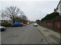
Brimrod: Holborn Street
The Brimrod estate was built by Rochdale Corporation just before World War II, using direct labour. However most of the houses have now passed into private ownership.
Image: © Dr Neil Clifton
Taken: 4 Jun 2013
0.21 miles
10
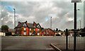
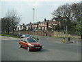
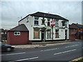
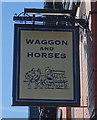
Wagon & Horses, Sudden Crossroads
Looking across Sudden Crossroads from Edinburgh Way to the Wagon and Horses public house.
Although still (July 2010) marked on the OS map as a roundabout, the intersection of Edinburgh Way (the A664, leading to the A627M and M62 motorways) with Manchester Road (the A58 to Rochdale, Manchester, Bury and Bolton) and Roch Valley Way (B6452 to Blackburn) has been re-designed.
The Sudden Roundabouts were two of the busiest junctions in Rochdale, often affected by congestion and delays, particularly during the morning and afternoon peaks.
http://www.theimpactpartnership.com/File.ashx?id=Case%20studies/Sudden%20Roundabouts.pdf
http://www.rochdaleonline.co.uk/news-features/councillor-diaries/531/an-apology-from-councillor-greg-couzens-cabinet-member-for-highways
Image] for the opposite view (from Roch Valley Way towards Edinburgh Way).
Image: © David Dixon
Taken: 21 Jul 2010
0.21 miles