IMAGES TAKEN NEAR TO
Olney, ROCHDALE, OL11 4LQ
Introduction
This page details the photographs taken nearby to Olney, OL11 4LQ by members of the Geograph project.
The Geograph project started in 2005 with the aim of publishing, organising and preserving representative images for every square kilometre of Great Britain, Ireland and the Isle of Man.

There are currently over 7.5m images from over14,400 individuals and you can help contribute to the project by visiting https://www.geograph.org.uk
Image Map
Images are licensed for reuse under creativecommons.org/licenses/by-sa/2.0
Notes
- Clicking on the map will re-center to the selected point.
- The higher the marker number, the further away the image location is from the centre of the postcode.
Image Listing (40 Images Found)
Images are licensed for reuse under creativecommons.org/licenses/by-sa/2.0
Image
Details
Distance
1
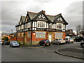
The Castle Inn, Rochdale
There are no visible remains of Rochdale Castle; a Saxon fortress which once stood on top of nearby Castle Hill, taking advantage of its position looking over the surrounding area of old Rochdale. Some streets in the area and this local pub, The Castle Inn on Manchester Road, are all named after the castle.
http://www.sparththenandnow.org.uk/medieval/castle/436/
Image: © David Dixon
Taken: 14 Jan 2011
0.08 miles
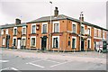
2
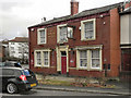
St Albans Hotel
St Albans Hotel, Manchester Road, Rochdale.
Image: © David Dixon
Taken: 14 Jan 2011
0.10 miles
3
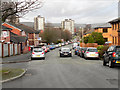
Manchester Road, Rochdale
Manchester Road, Sparth, Rochdale
Image: © David Dixon
Taken: 14 Jan 2011
0.10 miles
4
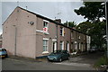
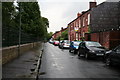
Healey Street, Rochdale, Lancashire
This short terrace of houses is off St Albans Street, near Broadfield Park.
Image: © Dr Neil Clifton
Taken: 9 Jul 2007
0.11 miles
5
St. Albans Street, Rochdale, Lancashire
St Albans Street runs along the edge of Broadfield Park.
Image: © Dr Neil Clifton
Taken: 9 Jul 2007
0.14 miles
6

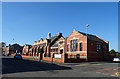
Castlemere Community Centre
On Tweedale Street the former Castlemere Board School 1893 is now a community centre http://www.castlemere.org.uk/.
On the left, in the background, is the minaret of the Castlemere Mosque.
Image: © Peter Thwaite
Taken: 21 Apr 2010
0.14 miles
7
Former Castlemere Board School
Now Castlemere Community Centre.
Image: © JThomas
Taken: 10 Oct 2018
0.15 miles
8
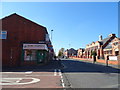
Tweedale Street, Rochdale
Looking south west.
Image: © JThomas
Taken: 10 Oct 2018
0.15 miles
9
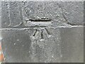
Ordnance Survey Cut Mark
This mark can be found on the roadside wall of a house in Drake Street, Rochdale.
The recorded details give a height of 145.1031 metres above sea level.
For more details see : https://www.bench-marks.org.uk/bm183722
Image: © Peter Wood
Taken: 7 Feb 2023
0.17 miles
10
The Queens, Tweedale Street. Rochdale, Lancashire
Image: © Dr Neil Clifton
Taken: 22 Mar 2004
0.17 miles