IMAGES TAKEN NEAR TO
Sparth Bottoms Road, ROCHDALE, OL11 4HW
Introduction
This page details the photographs taken nearby to Sparth Bottoms Road, OL11 4HW by members of the Geograph project.
The Geograph project started in 2005 with the aim of publishing, organising and preserving representative images for every square kilometre of Great Britain, Ireland and the Isle of Man.

There are currently over 7.5m images from over14,400 individuals and you can help contribute to the project by visiting https://www.geograph.org.uk
Image Map
Images are licensed for reuse under creativecommons.org/licenses/by-sa/2.0
Notes
- Clicking on the map will re-center to the selected point.
- The higher the marker number, the further away the image location is from the centre of the postcode.
Image Listing (15 Images Found)
Images are licensed for reuse under creativecommons.org/licenses/by-sa/2.0
Image
Details
Distance
1
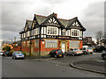
The Castle Inn, Rochdale
There are no visible remains of Rochdale Castle; a Saxon fortress which once stood on top of nearby Castle Hill, taking advantage of its position looking over the surrounding area of old Rochdale. Some streets in the area and this local pub, The Castle Inn on Manchester Road, are all named after the castle.
http://www.sparththenandnow.org.uk/medieval/castle/436/
Image: © David Dixon
Taken: 14 Jan 2011
0.09 miles
2
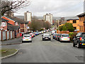
Manchester Road, Rochdale
Manchester Road, Sparth, Rochdale
Image: © David Dixon
Taken: 14 Jan 2011
0.09 miles
4
St Albans Hotel
St Albans Hotel, Manchester Road, Rochdale.
Image: © David Dixon
Taken: 14 Jan 2011
0.10 miles
5
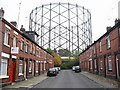
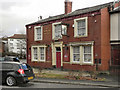
Briar Street Rochdale
With the huge Transco gas works at the far end this is Briar Street close to the town centre of Rochdale.
Red brick terraced houses of this type are a common feature in this area.
Image: © Paul Anderson
Taken: 19 Oct 2007
0.11 miles
6
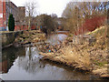
River Roch
The River Roch as it passes behind the derelict mill at Broadfield Street.
Image: © David Dixon
Taken: 10 Feb 2010
0.17 miles
7
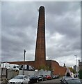
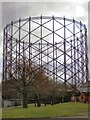
Brimrod Mill Chimney
On Norman Road, much of the former mill site is now a car dismantler's yard
Image: © Kevin Waterhouse
Taken: 31 Oct 2022
0.19 miles
8
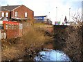
River Roch
The bridge at Mellor Street.
Image: © David Dixon
Taken: 10 Feb 2010
0.19 miles
9
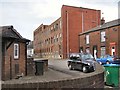
Bridgefield Mill
Derelict mill on Bridgefield Street.
Image: © David Dixon
Taken: 10 Feb 2010
0.20 miles
10
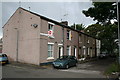
Healey Street, Rochdale, Lancashire
This short terrace of houses is off St Albans Street, near Broadfield Park.
Image: © Dr Neil Clifton
Taken: 9 Jul 2007
0.21 miles