IMAGES TAKEN NEAR TO
Oakenrod Hill, ROCHDALE, OL11 4EQ
Introduction
This page details the photographs taken nearby to Oakenrod Hill, OL11 4EQ by members of the Geograph project.
The Geograph project started in 2005 with the aim of publishing, organising and preserving representative images for every square kilometre of Great Britain, Ireland and the Isle of Man.

There are currently over 7.5m images from over14,400 individuals and you can help contribute to the project by visiting https://www.geograph.org.uk
Image Map
Images are licensed for reuse under creativecommons.org/licenses/by-sa/2.0
Notes
- Clicking on the map will re-center to the selected point.
- The higher the marker number, the further away the image location is from the centre of the postcode.
Image Listing (8 Images Found)
Images are licensed for reuse under creativecommons.org/licenses/by-sa/2.0
Image
Details
Distance
1
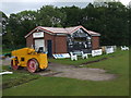
Rochdale Cricket Club - Scoreboard
The scoreboard at Rochdale CC's Redbrook ground.
Image: © BatAndBall
Taken: 16 Jun 2011
0.13 miles
2
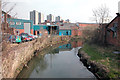
River Roch
To the east of Rochdale town centre
Image: © Dennis Turner
Taken: 26 Mar 2003
0.15 miles
3
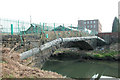
Old Bridge over the Roch
Now reduced to a footbridge.
Image: © Dennis Turner
Taken: 26 Mar 2003
0.15 miles
4
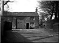
Coptrod Farm, Rochdale, Lancashire
Incredibly, in 1956, one could still photograph this rural scene within one mile of Rochdale Town Centre.
Note added 12 August 2013: Today I received an email from Mrs Judith Harding, who was living as a one-year old baby in the next cottage when this photograph was taken, informing me of the identity of the man shown: He was George Hodgkinson, known locally as Juddy Ockey.
Image: © Dr Neil Clifton
Taken: 22 Apr 1956
0.16 miles
5
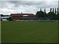
Rochdale Cricket Club - Pavilion
Rochdale Cricket Club play in the Central Lancashire League.
Their full title is Rochdale Cricket, Squash & Lacrosse Club. They moved from their Dane Street ground in the 1990's to the site of the old Redbrook Middle School. An ASDA store now stands on the old ground.
Image: © BatAndBall
Taken: 16 Jun 2011
0.19 miles
6
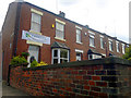
413 Bury Road, Rochdale
Terraced properties on the corner of Bury Road and Half Acre Drive in Rochdale, Greater Manchester, England. The house on the corner is number 413. Such red brick terraced houses are typical of this part of Rochdale, and of Greater Manchester as a whole.
Image: © Steven Haslington
Taken: 27 Jul 2011
0.21 miles
7
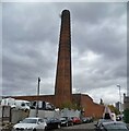
Brimrod Mill Chimney
On Norman Road, much of the former mill site is now a car dismantler's yard
Image: © Kevin Waterhouse
Taken: 31 Oct 2022
0.21 miles
8
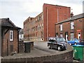
Bridgefield Mill
Derelict mill on Bridgefield Street.
Image: © David Dixon
Taken: 10 Feb 2010
0.23 miles