IMAGES TAKEN NEAR TO
Woodgate Avenue, ROCHDALE, OL11 4DW
Introduction
This page details the photographs taken nearby to Woodgate Avenue, OL11 4DW by members of the Geograph project.
The Geograph project started in 2005 with the aim of publishing, organising and preserving representative images for every square kilometre of Great Britain, Ireland and the Isle of Man.

There are currently over 7.5m images from over14,400 individuals and you can help contribute to the project by visiting https://www.geograph.org.uk
Image Map
Images are licensed for reuse under creativecommons.org/licenses/by-sa/2.0
Notes
- Clicking on the map will re-center to the selected point.
- The higher the marker number, the further away the image location is from the centre of the postcode.
Image Listing (19 Images Found)
Images are licensed for reuse under creativecommons.org/licenses/by-sa/2.0
Image
Details
Distance
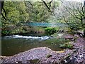
1
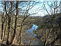
River Roch
Off the B6222, Bury Road is Chadwick Hall Road at the end of which is a delightful sunken path that leads down to woodland glades above the river bank. View looking east towards the sewage works.
Image: © michael ely
Taken: 9 Feb 2006
0.07 miles
2
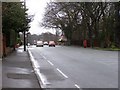
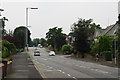
Bury Road
Bury Road, Rochdale; looking in the direction of Rochdale.
Image: © David Dixon
Taken: 2 Feb 2010
0.08 miles
3
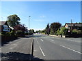
Bury Road, Rochdale
Looking south west on the B6222.
Image: © JThomas
Taken: 25 Sep 2018
0.11 miles
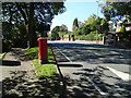
4

Elizabeth II postbox on Bury Road, Rochdale
Postbox No. OL11 120.
See Image] for context.
Image: © JThomas
Taken: 25 Sep 2018
0.12 miles
5
Bury Road, Rochdale (B6222)
Showing position of Postbox No. OL11 120.
See Image] for postbox.
Image: © JThomas
Taken: 25 Sep 2018
0.12 miles
6
Bury Road, Bamford
Most of Bamford is residential like this, with larger than average houses.
Image: © Bill Boaden
Taken: 26 Jul 2012
0.13 miles
7
River Roch Footbridge
The footbridge is across the river at a former weir at the site of Broadhalgh Fulling Mill
Image: © Kevin Waterhouse
Taken: 31 Oct 2022
0.18 miles
8
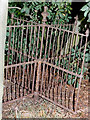
Kissing Gate?
I found this little treasure whilst walking through the woods at the rear of Springfield Park, I don't know how it was passed over when the war effort was collecting metal railings and the like. It still worked when I took this in 1995. I went back to look for it in 2002 armed with my brand new digital camera, sadly someone else had found it and destroyed it all that was left was a metal stump in the ground.
Image: © Jeff Mills
Taken: Unknown
0.19 miles
9
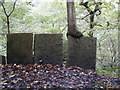
Tree on Flagstone wall.
The Flagstone wall is at the rear of the golf course leading down to the River Roche.
Image: © Jeff Mills
Taken: 17 Oct 2004
0.20 miles
10
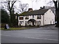
Elephant and Castle
Bury Road, Rochdale
Image: © David Dixon
Taken: 2 Feb 2010
0.21 miles