IMAGES TAKEN NEAR TO
Crimble Lane, ROCHDALE, OL11 4AB
Introduction
This page details the photographs taken nearby to Crimble Lane, OL11 4AB by members of the Geograph project.
The Geograph project started in 2005 with the aim of publishing, organising and preserving representative images for every square kilometre of Great Britain, Ireland and the Isle of Man.

There are currently over 7.5m images from over14,400 individuals and you can help contribute to the project by visiting https://www.geograph.org.uk
Image Map
Images are licensed for reuse under creativecommons.org/licenses/by-sa/2.0
Notes
- Clicking on the map will re-center to the selected point.
- The higher the marker number, the further away the image location is from the centre of the postcode.
Image Listing (30 Images Found)
Images are licensed for reuse under creativecommons.org/licenses/by-sa/2.0
Image
Details
Distance
1
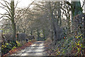
Crimble Lane
A view looking south down Crimble Lane.
Image: © Christopher Hill
Taken: 6 Jan 2008
0.08 miles
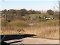
2
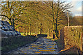
Crimble Lane
Taken outside Crimble Farm, looking North towards Bury Road.
Image: © Christopher Hill
Taken: 6 Jan 2008
0.10 miles
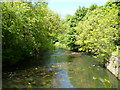
4
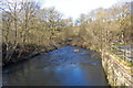
River Roch
View of the River Roch, looking downstream, taken from the bridge at the front of Crimble Mill.
Image: © Christopher Hill
Taken: 6 Jan 2008
0.15 miles
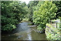
6
Crimble: River Roch
Looking downstream from Crimble
Image: © Dr Neil Clifton
Taken: 4 Jun 2013
0.17 miles
9
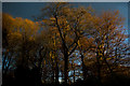
Trees in the evening sun
A sudden shaft of light from the setting sun catches this group of trees.
Image: © Christopher Hill
Taken: 8 Apr 2009
0.18 miles
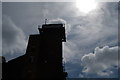
10
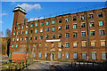
Crimble Mill
It may look derelict, but the mill is still in everyday use.
Image: © Christopher Hill
Taken: 6 Jan 2008
0.18 miles