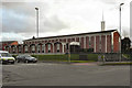
IMAGES TAKEN NEAR TO
Boundary Street, ROCHDALE, OL11 3TG
Introduction
This page details the photographs taken nearby to Boundary Street, OL11 3TG by members of the Geograph project.
The Geograph project started in 2005 with the aim of publishing, organising and preserving representative images for every square kilometre of Great Britain, Ireland and the Isle of Man.

There are currently over 7.5m images from over14,400 individuals and you can help contribute to the project by visiting https://www.geograph.org.uk
Image Map
Images are licensed for reuse under creativecommons.org/licenses/by-sa/2.0
Notes
- Clicking on the map will re-center to the selected point.
- The higher the marker number, the further away the image location is from the centre of the postcode.
Image Listing (48 Images Found)
Images are licensed for reuse under creativecommons.org/licenses/by-sa/2.0
Image
Details
Distance
1
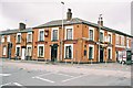
The Queens, Tweedale Street. Rochdale, Lancashire
Image: © Dr Neil Clifton
Taken: 22 Mar 2004
0.01 miles
2
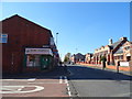
Tweedale Street, Rochdale
Looking south west.
Image: © JThomas
Taken: 10 Oct 2018
0.05 miles
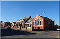
3

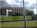
Castlemere Community Centre
On Tweedale Street the former Castlemere Board School 1893 is now a community centre http://www.castlemere.org.uk/.
On the left, in the background, is the minaret of the Castlemere Mosque.
Image: © Peter Thwaite
Taken: 21 Apr 2010
0.06 miles
4
Former Castlemere Board School
Now Castlemere Community Centre.
Image: © JThomas
Taken: 10 Oct 2018
0.07 miles
5
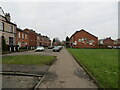
King Street South, Rochdale
Looking south-westward.
Image: © Peter Wood
Taken: 7 Feb 2023
0.10 miles
6
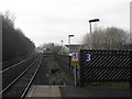
Local train approaching Rochdale station
An all-stations train from Manchester Victoria nears its terminus. It will use the remains of the former Oldham line to reverse direction, returning to Manchester (and on to Wigan Wallgate) at 12.04. For a contrasting, earlier view of this scene, see: http://www.geograph.org.uk/photo/820376.
Image: © Peter Whatley
Taken: 19 Jan 2011
0.13 miles
7
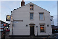
The Mormon Church in Rochdale
On the corner of Tweedale Street and Manchester Road (taken from a bus).
Image: © Bill Boaden
Taken: 2 Jul 2010
0.15 miles
8
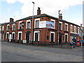
Rochdale: The 'Queens', Tweedale Street
When I first photographed the 'Queens', I got a First Geograph point for it. The 'Queens' was then still open. There are now some 90 images for this gridsquare, and the pub. is closed, probably permanently.
Image: © Dr Neil Clifton
Taken: 18 Mar 2011
0.16 miles
10
The Church of Jesus Christ of Latter Day Saints
The Church of Jesus Christ of Latter Day Saints, Rochdale. At the junction of Tweedale Street and Manchester Road.
Image: © David Dixon
Taken: 14 Jan 2011
0.17 miles