IMAGES TAKEN NEAR TO
Monmouth Street, ROCHDALE, OL11 3SZ
Introduction
This page details the photographs taken nearby to Monmouth Street, OL11 3SZ by members of the Geograph project.
The Geograph project started in 2005 with the aim of publishing, organising and preserving representative images for every square kilometre of Great Britain, Ireland and the Isle of Man.

There are currently over 7.5m images from over14,400 individuals and you can help contribute to the project by visiting https://www.geograph.org.uk
Image Map
Images are licensed for reuse under creativecommons.org/licenses/by-sa/2.0
Notes
- Clicking on the map will re-center to the selected point.
- The higher the marker number, the further away the image location is from the centre of the postcode.
Image Listing (219 Images Found)
Images are licensed for reuse under creativecommons.org/licenses/by-sa/2.0
Image
Details
Distance
3
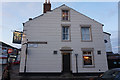
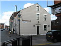
Rochdale: The 'Queens', Tweedale Street
When I first photographed the 'Queens', I got a First Geograph point for it. The 'Queens' was then still open. There are now some 90 images for this gridsquare, and the pub. is closed, probably permanently.
Image: © Dr Neil Clifton
Taken: 18 Mar 2011
0.06 miles
4
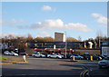
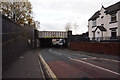
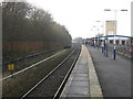
Rochdale Railway Station
Looking from Tweedale Street. A train is waiting on one of the platforms and many white taxis are waiting outside.
Image: © michael ely
Taken: 28 Nov 2006
0.06 miles
5
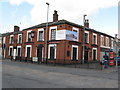
Rochdale: The 'Corporation Inn', Lower Tweedale Street
Like the 'Queens' across the other side of Milkstone Road, the 'Corporation' is closed, almost certainly permanently. Within this grid square, five public houses have now closed since Geograph began: only the 'Weavers Arms' on Ashfield Road still soldiers on. For reference the closures are: 'Navigation', 'Woolpack', 'Queens', 'Commercial', and 'Brown Cow'. This is really getting to crisis proportions!
Image: © Dr Neil Clifton
Taken: 18 Mar 2011
0.06 miles
6
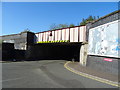
Railway bridge over Milkstone Road, Rochdale
Image: © JThomas
Taken: 10 Oct 2018
0.07 miles
8
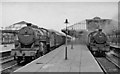
Rochdale Station, with trains
View NE from south end of the station; ex-Lancashire & Yorkshire Calder Valley main line, Manchester (Victoria) - Rochdale - Todmorden - Sowerby Bridge - Bradford/Leeds, Wakefield etc., junction of lines from Bolton via Bury and from Bacup. On the left, Hughes/Fowler 5P4F 2-6-0 No. 42724 on the 11.58 Wakefield to Manchester; on the right, Stanier 4MT 2-6-4T No. 42653 on a local to Bolton.
Image: © Ben Brooksbank
Taken: 10 Jun 1959
0.08 miles
9
Rochdale station, looking toward Manchester
The view south shows one platform edge of the former Manchester side of the station, as large again as the current station and taken out of use in the 1970s. The yellow sign on the left indicates 10.5 miles from Manchester Victoria via the original Manchester & Leeds Railway route via Miles Platting.
Image: © Peter Whatley
Taken: 19 Jan 2011
0.08 miles
10
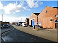
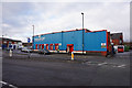
Haji Cash and Carry
Haji Food Store started in 1955 by two brothers from a small shop on Tweedale Street in Rochdale. The shop catered mostly to the Asian section of what was known as the North's Little Pakistan. It has since grown to become Haji Cash & Carry, operating from a wholesale and corporate 8000 sq feet Headquarters located on Station Approach, Lower Tweedale Street. http://web.archive.org/web/20161122204137/http://www.haji.co.uk/haji-cash-carry
Note: Photograph is for record purposes only. The photographer has no connection with the business depicted.
Image: © Gerald England
Taken: 4 Feb 2017
0.08 miles