IMAGES TAKEN NEAR TO
Ellesmere Street, ROCHDALE, OL11 3SU
Introduction
This page details the photographs taken nearby to Ellesmere Street, OL11 3SU by members of the Geograph project.
The Geograph project started in 2005 with the aim of publishing, organising and preserving representative images for every square kilometre of Great Britain, Ireland and the Isle of Man.

There are currently over 7.5m images from over14,400 individuals and you can help contribute to the project by visiting https://www.geograph.org.uk
Image Map
Images are licensed for reuse under creativecommons.org/licenses/by-sa/2.0
Notes
- Clicking on the map will re-center to the selected point.
- The higher the marker number, the further away the image location is from the centre of the postcode.
Image Listing (51 Images Found)
Images are licensed for reuse under creativecommons.org/licenses/by-sa/2.0
Image
Details
Distance
1
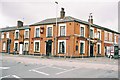
The Queens, Tweedale Street. Rochdale, Lancashire
Image: © Dr Neil Clifton
Taken: 22 Mar 2004
0.06 miles
2
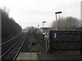
Local train approaching Rochdale station
An all-stations train from Manchester Victoria nears its terminus. It will use the remains of the former Oldham line to reverse direction, returning to Manchester (and on to Wigan Wallgate) at 12.04. For a contrasting, earlier view of this scene, see: http://www.geograph.org.uk/photo/820376.
Image: © Peter Whatley
Taken: 19 Jan 2011
0.09 miles
3
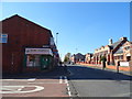
Tweedale Street, Rochdale
Looking south west.
Image: © JThomas
Taken: 10 Oct 2018
0.11 miles
4
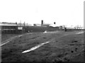
Waste Ground outside Riley's Spring Works
I celebrated my 21st birthday by taking this photograph of waste ground outside the spring works. In those days. nobody bothered about air pollution. Engines would stand on the sidings for hours emitting smoke and steam, while additional smoke was caused by Riley's workmen setting fire to waste rubber outside the works.
Image: © Dr Neil Clifton
Taken: 4 Jun 1956
0.11 miles
5
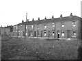
Terrace houses, Osborne Street, Rochdale, Lancashire
These houses, which still exist, were, when photographed in 1949, almost in "as built" condition, with sash windows, and facing onto an unmade road with gas lamps.
Image: © Dr Neil Clifton
Taken: 9 Jul 1949
0.11 miles
6

Castlemere Community Centre
On Tweedale Street the former Castlemere Board School 1893 is now a community centre http://www.castlemere.org.uk/.
On the left, in the background, is the minaret of the Castlemere Mosque.
Image: © Peter Thwaite
Taken: 21 Apr 2010
0.12 miles
7
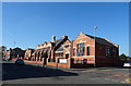
Former Castlemere Board School
Now Castlemere Community Centre.
Image: © JThomas
Taken: 10 Oct 2018
0.12 miles
8
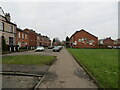
King Street South, Rochdale
Looking south-westward.
Image: © Peter Wood
Taken: 7 Feb 2023
0.12 miles
9
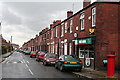
Ashfield Road, Rochdale, looking southwest
This is the view to the south-west from Deeplish Corner. This view has not changed in any material aspect for the last 60 years, with the exception that the road was the sett-paved - and the introduction of speed bumps is quite recent.
Image: © Dr Neil Clifton
Taken: 9 Jul 2007
0.12 miles
10

Osborne Street, Rochdale, Lancashire
For a photograph at the same location some 58 years earlier, see Image Trees prevents use of exactly the same viewpoint for the 2007 picture.
Image: © Dr Neil Clifton
Taken: 9 Jul 2007
0.13 miles