IMAGES TAKEN NEAR TO
Abingdon Close, ROCHDALE, OL11 3PU
Introduction
This page details the photographs taken nearby to Abingdon Close, OL11 3PU by members of the Geograph project.
The Geograph project started in 2005 with the aim of publishing, organising and preserving representative images for every square kilometre of Great Britain, Ireland and the Isle of Man.

There are currently over 7.5m images from over14,400 individuals and you can help contribute to the project by visiting https://www.geograph.org.uk
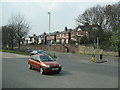
Image Map
Images are licensed for reuse under creativecommons.org/licenses/by-sa/2.0
Notes
- Clicking on the map will re-center to the selected point.
- The higher the marker number, the further away the image location is from the centre of the postcode.
Image Listing (15 Images Found)
Images are licensed for reuse under creativecommons.org/licenses/by-sa/2.0
Image
Details
Distance
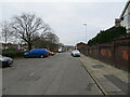
1
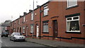
306 to 294 Ashfield Road, Rochdale
From left to right are house numbers 306 through to 294 of Ashfield Road, in the Stoneyfield area of Rochdale, Greater Manchester, England. Such red-brick terraced houses are typical of the neighbourhood, of Rochdale, and of Greater Manchester.
Image: © Steven Haslington
Taken: 11 Nov 2011
0.09 miles
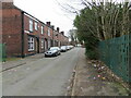
2
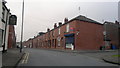
Ashfield Road, Rochdale
A view down Ashfield Road at its junction with Vivian Street in the Deeplish area of Rochdale, Greater Manchester, England.
Image: © Steven Haslington
Taken: 11 Nov 2011
0.12 miles
3

Rochdale: The 'Weavers Arms', Ashfield Road
Still soldiering on as the only remaining pub in Deeplish.
Image: © Dr Neil Clifton
Taken: 4 Aug 2010
0.13 miles
5
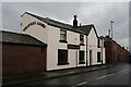
The 'Weavers Arms', Ashfield Road, Rochdale, Lancashire
The Weavers Arms survives as the only remaining pub. in Deeplish, the 'Brown Cow' on Milkstone Road having given up the ghost some time ago.
Image: © Dr Neil Clifton
Taken: 9 Jul 2007
0.18 miles
6
Manchester Road, Sudden
The original course of the road is in the background, superseded by the much wider highway now in use.
Image: © Peter Whatley
Taken: 25 Mar 2011
0.21 miles
7
Cheltenham Street, Rochdale
Looking south-eastward.
Image: © Peter Wood
Taken: 7 Feb 2023
0.22 miles
8
Manchester Road (old), Rochdale
Looking south-westward. I have added 'old' to the title as a modern dual carriage way road (A58) to the left of the picture is also called Manchester Road.
Image: © Peter Wood
Taken: 7 Feb 2023
0.22 miles
9
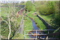
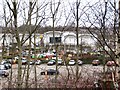
Sudden Brook
Upstream from the culverted section.
Image: © Paul Hogg
Taken: 18 Apr 2009
0.23 miles
10
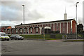
The Church of Jesus Christ of Latter Day Saints
The Church of Jesus Christ of Latter Day Saints, Rochdale. At the junction of Tweedale Street and Manchester Road.
Image: © David Dixon
Taken: 14 Jan 2011
0.24 miles