IMAGES TAKEN NEAR TO
Matthew Moss Lane, ROCHDALE, OL11 3LX
Introduction
This page details the photographs taken nearby to Matthew Moss Lane, OL11 3LX by members of the Geograph project.
The Geograph project started in 2005 with the aim of publishing, organising and preserving representative images for every square kilometre of Great Britain, Ireland and the Isle of Man.

There are currently over 7.5m images from over14,400 individuals and you can help contribute to the project by visiting https://www.geograph.org.uk
Image Map
Images are licensed for reuse under creativecommons.org/licenses/by-sa/2.0
Notes
- Clicking on the map will re-center to the selected point.
- The higher the marker number, the further away the image location is from the centre of the postcode.
Image Listing (7 Images Found)
Images are licensed for reuse under creativecommons.org/licenses/by-sa/2.0
Image
Details
Distance
1
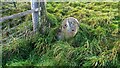
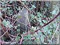
Old Boundary Marker
A typical Rochdale boundary marker with its metal plate missing. This is on an overgrown path south of Francil
Image: © Kevin Waterhouse
Taken: 10 Oct 2022
0.06 miles
2
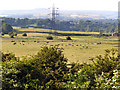
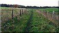
The track from Francil
Francil is a small collection of houses, mostly terraced, and this track is its only connection with the outside world. The land is the green space between Rochdale and Heywood. Scout Moor Wind Farm is on the skyline.
Image: © Bill Boaden
Taken: 14 Jul 2011
0.06 miles
3
View towards Francil
View from Chadwick lane towards Francil (shown as "France Hill" on the 1940s OS map)
Image: © David Dixon
Taken: 22 Jun 2010
0.11 miles
4
Boundary Stone
In undergrowth rear of Chamber House. Plate missing.
Image: © Alan Valentine
Taken: 6 Oct 2008
0.11 miles
5
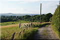
Rochdale Way near Francil
Francil is behind the camera and the path leads to Chadwick Lane
Image: © Kevin Waterhouse
Taken: 10 Oct 2022
0.12 miles
6
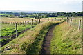
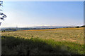
The Rochdale Way towards Francil
The view looks over the Roch valley towards Knowl Moor and Scout Moor. This is the green space between Rochdale and Heywood.
Image: © Bill Boaden
Taken: 14 Jul 2011
0.13 miles