IMAGES TAKEN NEAR TO
Broche Close, ROCHDALE, OL11 3LT
Introduction
This page details the photographs taken nearby to Broche Close, OL11 3LT by members of the Geograph project.
The Geograph project started in 2005 with the aim of publishing, organising and preserving representative images for every square kilometre of Great Britain, Ireland and the Isle of Man.

There are currently over 7.5m images from over14,400 individuals and you can help contribute to the project by visiting https://www.geograph.org.uk
Image Map
Images are licensed for reuse under creativecommons.org/licenses/by-sa/2.0
Notes
- Clicking on the map will re-center to the selected point.
- The higher the marker number, the further away the image location is from the centre of the postcode.
Image Listing (17 Images Found)
Images are licensed for reuse under creativecommons.org/licenses/by-sa/2.0
Image
Details
Distance
1
Boundary Stone
In undergrowth rear of Chamber House. Plate missing.
Image: © Alan Valentine
Taken: 6 Oct 2008
0.13 miles
2
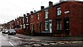
Terraced Houses on Crescent Road, Rochdale
Image: © Stephen Armstrong
Taken: 13 Feb 2022
0.15 miles
3
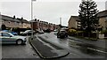
Crescent Road, Rochdale
Just a short section of a fairly long residential road with a mixture of, probably, ex-Local Authority housing & private terraced housing.
Image: © Stephen Armstrong
Taken: 13 Feb 2022
0.16 miles
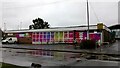
4
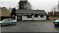
The Anti Ageing Clinic, Crescent Road, Rochdale
Image: © Stephen Armstrong
Taken: 13 Feb 2022
0.16 miles
5
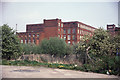
Mars Mill, Rochdale
Now demolished. The fine engine house is visible and the blind wall containing the rope race. At the extreme right is the corner of Marland Mill.
Image: © Chris Allen
Taken: 5 May 1990
0.17 miles
6
Carders Court Care Village, Ivor Street, Castleton
A specialist care village offering residential, nursing, respite and dementia care. Built on the site of the former Mars Cotton Spinning Mill which was demolished in the 1990s.
Image: © Stephen Armstrong
Taken: 27 Mar 2022
0.18 miles
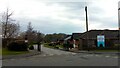
7
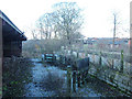
Sheep pens, derelict urban farm, Heywood
Little Bo-Peep has lost her sheep. This farm is still shown on the 1/50,000 OS map as a tourist attraction. Urban farms were used to introduce inner-city children to farm animals and to educate them about the source of their food.
Image: © michael ely
Taken: 6 Dec 2005
0.18 miles
8
Matthew Moss Youth Centre, Rochdale
Situated on Matthew Moss Lane, next to the High School.
Image: © Stephen Armstrong
Taken: 13 Feb 2022
0.18 miles
9
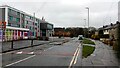
Matthew Moss Lane, Rochdale
Looking towards Bolton Road from Crescent Road, with Matthew Moss High School on the left.
Image: © Stephen Armstrong
Taken: 13 Feb 2022
0.18 miles
10

Lily Beetle, (Lilioceris lilii)
A Scarlet Lily Beetle, munching on the good ladys lilies.
Image: © Jeff Mills
Taken: 28 Apr 2007
0.18 miles