IMAGES TAKEN NEAR TO
Adair Street, ROCHDALE, OL11 3DH
Introduction
This page details the photographs taken nearby to Adair Street, OL11 3DH by members of the Geograph project.
The Geograph project started in 2005 with the aim of publishing, organising and preserving representative images for every square kilometre of Great Britain, Ireland and the Isle of Man.

There are currently over 7.5m images from over14,400 individuals and you can help contribute to the project by visiting https://www.geograph.org.uk
Image Map
Images are licensed for reuse under creativecommons.org/licenses/by-sa/2.0
Notes
- Clicking on the map will re-center to the selected point.
- The higher the marker number, the further away the image location is from the centre of the postcode.
Image Listing (39 Images Found)
Images are licensed for reuse under creativecommons.org/licenses/by-sa/2.0
Image
Details
Distance
1
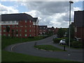
Keswick Street - Castleton Moor Cricket Club
The picture shows the housing development on the Keswick Street ground of Castleton Moor Cricket Club who used to play in the Central Lancashire League.
As the cricket club struggled into the 1980's, Mayfield Amateur Rugby League Club became partners in the ground but when the cricket folded in 1987, it passed to them. In 2005, Mayfield sold the ground for housing and moved into the nearby Butterworth Park to ground-share with Castleton Gabriels FC.
The old cricket pavilion was on a slope to the left of the photograph and the extension to Keswick Street passes right over the old cricket square.
Image: © BatAndBall
Taken: 19 Jun 2011
0.13 miles
2
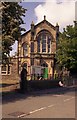
United Reformed Church, Castleton, Rochdale
This former Congregational Church has now become the local United Reformed Church. A former Methodist chapel that once stood within 100 yards, has now disappeared completely.
Image: © Dr Neil Clifton
Taken: 31 May 2004
0.13 miles
3
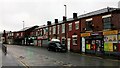
Local Shops, Houses and a Church on Manchester Road, Castleton
The church, near the left edge of the photo, is Castleton Moor Methodist Church.
Image: © Stephen Armstrong
Taken: 13 Feb 2022
0.15 miles
4
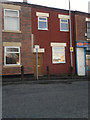
732 Manchester Road, Castleton
732 Manchester Road, a terraced house in the Castleton area of Rochdale, Greater Manchester, England. Such red-brick properties are typical of Castleton, Rochdale and Greater Manchester as a whole.
Image: © Steven Haslington
Taken: 19 Oct 2011
0.16 miles
5
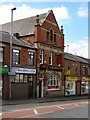
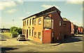
Midland Beer Company
Manchester Road, Castleton.
Image: © David Dixon
Taken: 20 Apr 2010
0.17 miles
6
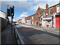
Manchester Road, Castleton
The A664 towards Rochdale.
Image: © Gerald England
Taken: 29 Feb 2020
0.17 miles
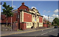
9
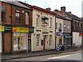
Directors' Arms, Castleton, Rochdale, Lancashire
A pub with a unique name, which arose from its use by the Directors of the nearby Manchester and Leeds Railway for their meetings. The directors are represented by the fine, though faded now, sign on the end wall. The future for this pub does not look good - at the time of the photograph it was empty and for sale.
Image: © Dr Neil Clifton
Taken: 31 May 2004
0.18 miles
10
Public Swimming Baths, Castleton, Rochdale, Lancashire
In former days, local authorities took their responsibilities very seriously and were always striving to improve the environment for their residents. This fine Public Baths building was constructed by the Borough of Rochdale shortly after the Urban District of Castleton had been absorbed into Rochdale, (the actual date of this being 9 April 1900) and are still in use, having provided recreational facilities for many thousands of working-class people over the years.
Image: © Dr Neil Clifton
Taken: 31 May 2004
0.19 miles