IMAGES TAKEN NEAR TO
Heywood Road, ROCHDALE, OL11 3AU
Introduction
This page details the photographs taken nearby to Heywood Road, OL11 3AU by members of the Geograph project.
The Geograph project started in 2005 with the aim of publishing, organising and preserving representative images for every square kilometre of Great Britain, Ireland and the Isle of Man.

There are currently over 7.5m images from over14,400 individuals and you can help contribute to the project by visiting https://www.geograph.org.uk
Image Map
Images are licensed for reuse under creativecommons.org/licenses/by-sa/2.0
Notes
- Clicking on the map will re-center to the selected point.
- The higher the marker number, the further away the image location is from the centre of the postcode.
Image Listing (98 Images Found)
Images are licensed for reuse under creativecommons.org/licenses/by-sa/2.0
Image
Details
Distance
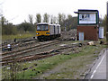
2
The slow train to Leeds
It is about to stop in Castleton station, on the other side of the bridge under the A664.
Image: © Bill Boaden
Taken: 14 Jul 2011
0.02 miles
3
Directors' Arms, Castleton, Rochdale, Lancashire
A pub with a unique name, which arose from its use by the Directors of the nearby Manchester and Leeds Railway for their meetings. The directors are represented by the fine, though faded now, sign on the end wall. The future for this pub does not look good - at the time of the photograph it was empty and for sale.
Image: © Dr Neil Clifton
Taken: 31 May 2004
0.02 miles
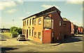
4
Midland Beer Company
Manchester Road, Castleton.
Image: © David Dixon
Taken: 20 Apr 2010
0.04 miles
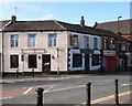
5
Top House
The Top House public house.
Image: © Peter McDermott
Taken: 25 May 2020
0.04 miles
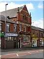
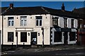
6
Top House
The pub on the corner of Manchester Road and Heywood Street has been closed for than a decade.
Image
Image: © Gerald England
Taken: 29 Feb 2020
0.04 miles
7
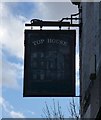
The sign of the Top House
The sign for the Top House Image
Image: © Gerald England
Taken: 29 Feb 2020
0.05 miles
8
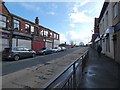
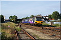
Manchester Road, Castleton
The A664 near Castleton Station.
Image: © Gerald England
Taken: 29 Feb 2020
0.05 miles
9
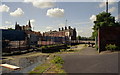
Blue Pits Top Lock, Castleton, Rochdale, Lancashire.
When the Rochdale Canal was built in the latter part of the eighteenth century, the nearby village, now known as Castleton, was called Blue Pits, hence the name of this lock, which is right in the centre of Castleton and adjoins the railway station, (behind the photographer). The spire of St. Martin's Church is visible, (left background).
Image: © Dr Neil Clifton
Taken: 31 May 2004
0.05 miles
10
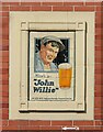
Mine's a ?John Willie?
Ceramic advertising panel on the side of the Blue Pits Inn. The pub is owned by J.W.Lees who are still independent brewers near Oldham. The panel probably dates to the 1930s.
Image: © Alan Murray-Rust
Taken: 8 Apr 2022
0.05 miles