IMAGES TAKEN NEAR TO
Chatburn Square, ROCHDALE, OL11 2YF
Introduction
This page details the photographs taken nearby to Chatburn Square, OL11 2YF by members of the Geograph project.
The Geograph project started in 2005 with the aim of publishing, organising and preserving representative images for every square kilometre of Great Britain, Ireland and the Isle of Man.

There are currently over 7.5m images from over14,400 individuals and you can help contribute to the project by visiting https://www.geograph.org.uk
Image Map
Images are licensed for reuse under creativecommons.org/licenses/by-sa/2.0
Notes
- Clicking on the map will re-center to the selected point.
- The higher the marker number, the further away the image location is from the centre of the postcode.
Image Listing (10 Images Found)
Images are licensed for reuse under creativecommons.org/licenses/by-sa/2.0
Image
Details
Distance
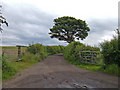
2
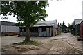
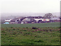
Newhey Farm
Apart from the usual barns, it has a lot of sheds and garages. It is surprisingly clean.
Image: © Bill Boaden
Taken: 23 Jun 2010
0.11 miles
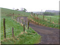
5
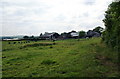
Track to Thornfields
This shot is taken from the junction with Thornham New Road to the east of Trub. The track provides access to Thornfields Farm and also serves as a footpath to Thornham Old Road and Tandle Hill Country Park.
Image: © michael ely
Taken: 23 Jun 2007
0.15 miles
6
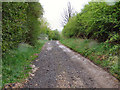
Thornham New Road
Despite its name, Thornham New Road soon peters out into a track.
Image: © David Dixon
Taken: 29 Apr 2010
0.16 miles
7
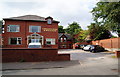
Castleton Hotel
This used to be the South East Lancs Area Office of NatWest Bank about 30 years ago until internal reorganisation meant that they didn't need it any more. There is a bowling green on the other side of the wall on the right.
Image: © Bill Boaden
Taken: 23 Jun 2010
0.17 miles
9
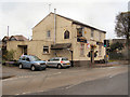
Junction
Public house at the corner of Thornham New Road and Rochdale road.
Image: © David Dixon
Taken: 29 Apr 2010
0.19 miles
10
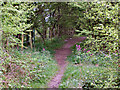
Public Footpath
A public footpath through the woodland between Thornham New Road and the westbound carriageway of the M62.
Image: © David Dixon
Taken: 29 Apr 2010
0.22 miles