IMAGES TAKEN NEAR TO
Thornham New Road, ROCHDALE, OL11 2XW
Introduction
This page details the photographs taken nearby to Thornham New Road, OL11 2XW by members of the Geograph project.
The Geograph project started in 2005 with the aim of publishing, organising and preserving representative images for every square kilometre of Great Britain, Ireland and the Isle of Man.

There are currently over 7.5m images from over14,400 individuals and you can help contribute to the project by visiting https://www.geograph.org.uk
Image Map
Images are licensed for reuse under creativecommons.org/licenses/by-sa/2.0
Notes
- Clicking on the map will re-center to the selected point.
- The higher the marker number, the further away the image location is from the centre of the postcode.
Image Listing (39 Images Found)
Images are licensed for reuse under creativecommons.org/licenses/by-sa/2.0
Image
Details
Distance
1
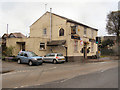
Junction
Public house at the corner of Thornham New Road and Rochdale road.
Image: © David Dixon
Taken: 29 Apr 2010
0.01 miles
2
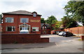
Castleton Hotel
This used to be the South East Lancs Area Office of NatWest Bank about 30 years ago until internal reorganisation meant that they didn't need it any more. There is a bowling green on the other side of the wall on the right.
Image: © Bill Boaden
Taken: 23 Jun 2010
0.11 miles
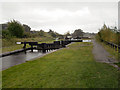
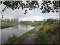
3
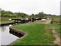
Rochdale Canal, Lock 53 at Trub
Looking south, towards Slattocks.
Image: © David Dixon
Taken: 29 Apr 2010
0.13 miles
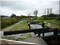
4
Rochdale Canal Lock 53
The lock at Trub, south of Castleton. Looking towards the M62 motorway (Image]).
Image: © David Dixon
Taken: 29 Apr 2010
0.13 miles
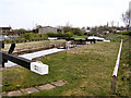
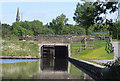
5
Rochdale Canal Lock#53 (Blue Pits New Lock)
Before the construction of the M62, the original lock#53 was further north (on the other side of the motorway) where the canal dropped 9 feet. Following the construction of the M62, the old lock was abandoned and the canal was allowed to stay level, diverted under the motorway via a new channel. The new lock 53 (Blue Pits New Lock) was then constructed to the south of the motorway (see http://www.penninewaterways.co.uk/rochdale/rc54.htm for more details).
Image: © David Dixon
Taken: 12 Oct 2012
0.13 miles
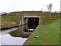
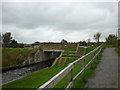
8
Bridge 65a
Rochdale Canal, just below Blue Pits New Lock. This was constructed to allow the canal to pass under the M62 which was built over the canal which was at the time abandoned and without prospect of restoration. The new line of the canal uses a culvert which was part of the original motorway embankment.
Image: © Mike Todd
Taken: 14 Jun 2011
0.13 miles
10
Rochdale Canal, old and new lines at Trub
Image: © John Slater
Taken: 17 Oct 2013
0.14 miles