IMAGES TAKEN NEAR TO
Manchester Road, ROCHDALE, OL11 2XG
Introduction
This page details the photographs taken nearby to Manchester Road, OL11 2XG by members of the Geograph project.
The Geograph project started in 2005 with the aim of publishing, organising and preserving representative images for every square kilometre of Great Britain, Ireland and the Isle of Man.

There are currently over 7.5m images from over14,400 individuals and you can help contribute to the project by visiting https://www.geograph.org.uk
Image Map
Images are licensed for reuse under creativecommons.org/licenses/by-sa/2.0
Notes
- Clicking on the map will re-center to the selected point.
- The higher the marker number, the further away the image location is from the centre of the postcode.
Image Listing (56 Images Found)
Images are licensed for reuse under creativecommons.org/licenses/by-sa/2.0
Image
Details
Distance
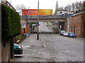
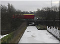
1
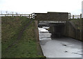
Bridge 65a Rochdale Canal near Trub
This bridge is where the footpath is interrupted. It was built when the canal was restored to navigation and since then pedestrians and cyclists have to detour via Manchester Road and Earl Street.
Image: © michael ely
Taken: 19 Jan 2010
0.03 miles
3
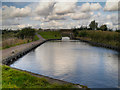
Rochdale Canal at Trub
Looking from just north of the Motorway, towards the new bridge (number 65a) built to provide access to land on the west side of the canal. The towpath crosses the bridge to change sides via this bridge. Originally a swing bridge crossed the canal roughly where the motorway now is.
The canal widens on the left forming a "layby" to where the floating towpath pontoon is moved to allow full width boats to pass through the tunnel Image], it is not a mooring for boats!
http://www.penninewaterways.co.uk/rochdale/rc8b.htm Pennine Waterways Virtual Journey Along The Rochdale Canal
Image: © David Dixon
Taken: 12 Oct 2012
0.06 miles
4
Trub
At Trub, near Rochdale, the restored Rochdale Canal passes below the M62 motorway through a tunnel that was formerly a farm access road.
Image: © Martin Clark
Taken: Unknown
0.07 miles
5
Rochdale Road
The bridge carrying the M62 motorway over Rochdale Road (A664) south of Castleton.
Image: © David Dixon
Taken: 29 Apr 2010
0.08 miles
6
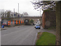
M62 Crossing Rochdale Road
The bridge carrying the M62 motorway over Rochdale Road (A664).
Image: © David Dixon
Taken: 29 Apr 2010
0.08 miles
7
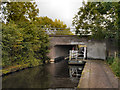
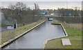
Rochdale Canal, Tunnel Under M62 (Bridge#65b)
When the M62 was constructed, the canal was diverted along a new channel, few yards to the east, and this former culvert was made into a tunnel. The towpath now runs on a floating pontoon in the tunnel under the M62 motorway.
The tunnel is just wide enough to allow a narrow boat to pass through with the pontoon in place (http://www.penninewaterways.co.uk/rochdale/rc8b.htm photo). If a wide beam boat arranges to pass through, the pontoon is moved to the layby (behind the camera, north of the tunnel - see Image]) and towpath users need to make quite a long diversion!.
http://www.penninewaterways.co.uk/rochdale/rc8b.htm Pennine Waterways Virtual Journey Along The Rochdale Canal
Image: © David Dixon
Taken: 12 Oct 2012
0.08 miles
8
![Motorway Culvert Bridge [No 65B], Rochdale Canal](https://s2.geograph.org.uk/geophotos/03/98/10/3981002_8956f942_120x120.jpg)
Motorway Culvert Bridge [No 65B], Rochdale Canal
A diversion for the restored canal. The floating towpath was designed to move out of the way [with 24 hours notice] if a boat wider than a narrowboat wants to pass through.
Image: © Christine Johnstone
Taken: 7 May 2014
0.08 miles
9
Old Lock (ex no 53) Rochdale Canal near Castleton
This lock is no longer in use. When the canal was restored to navigation a new lock no 53 was built to the south of the M62 motorway see http://www.geograph.org.uk/photo/475269
Image: © michael ely
Taken: 19 Jan 2010
0.09 miles
10
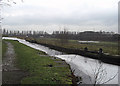
M62 crossing the Rochdale Canal
Here we are looking south from just south of Castleton. A towpath wasn't provided as part of the regeneration works so pedestrians and cyclists have to make a detour via Manchester Road and Earl Street.
Image: © michael ely
Taken: 19 Jan 2010
0.09 miles