IMAGES TAKEN NEAR TO
Leander Drive, ROCHDALE, OL11 2XD
Introduction
This page details the photographs taken nearby to Leander Drive, OL11 2XD by members of the Geograph project.
The Geograph project started in 2005 with the aim of publishing, organising and preserving representative images for every square kilometre of Great Britain, Ireland and the Isle of Man.

There are currently over 7.5m images from over14,400 individuals and you can help contribute to the project by visiting https://www.geograph.org.uk
Image Map
Images are licensed for reuse under creativecommons.org/licenses/by-sa/2.0
Notes
- Clicking on the map will re-center to the selected point.
- The higher the marker number, the further away the image location is from the centre of the postcode.
Image Listing (9 Images Found)
Images are licensed for reuse under creativecommons.org/licenses/by-sa/2.0
Image
Details
Distance
1
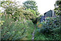
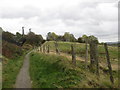
Path on the edge of the estate
To the right is the back of Leander Drive. To the left are open fields.
Image: © Bill Boaden
Taken: 2 Sep 2010
0.08 miles
2
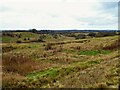
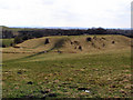
Rough pasture around a dry valley
View from Cripple Gate Lane towards Trows Farm
Image: © Kevin Waterhouse
Taken: 5 Dec 2022
0.15 miles
3
Scout Moor from Castleton
From this deceptively rural looking part of Castleton, in Rochdale, appears the tower and chimney of Arrow Mill, and beyond that, Scout Moor Wind Farm.
Image: © Steven Haslington
Taken: 16 Oct 2009
0.16 miles
4
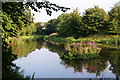
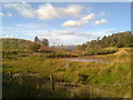
Fishing lodge on Trows Lane
A former mill reservoir, this is now devoted to fishing.
Image: © Bill Boaden
Taken: 2 Sep 2010
0.18 miles
5
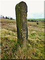
Benchmarked Stone
This stone appears too well dressed and slender to be a farm gatepost and it stands isolated on Cripple Gate Lane. Old OS maps have the benchmark as BM 588.7
Image: © Kevin Waterhouse
Taken: 5 Dec 2022
0.20 miles
6
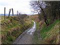
Cripple Gate Lane
Although shown as a byway on the OS Explorer map, this leads to a relatively narrow bridge over the A627(M), with access controls at the other (Kirkholt) side
Image: © John Slater
Taken: 18 Oct 2014
0.21 miles
8
Looking South from Cripple Gate Lane
View over farmland from Cripple Gate Lane towards the M62 motorway.
Image: © David Dixon
Taken: 25 Mar 2010
0.22 miles
9
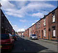
Newchurch Street, Castleton
A view up Newchurch Street, in the Castleton area of Rochdale, Greater Manchester, England. These red-brick terraced houses are typical of much of Castleton, of Rochdale, and of Greater Manchester in general.
Image: © Steven Haslington
Taken: 6 Jul 2011
0.24 miles