IMAGES TAKEN NEAR TO
Hogarth Road, ROCHDALE, OL11 2QS
Introduction
This page details the photographs taken nearby to Hogarth Road, OL11 2QS by members of the Geograph project.
The Geograph project started in 2005 with the aim of publishing, organising and preserving representative images for every square kilometre of Great Britain, Ireland and the Isle of Man.

There are currently over 7.5m images from over14,400 individuals and you can help contribute to the project by visiting https://www.geograph.org.uk
Image Map
Images are licensed for reuse under creativecommons.org/licenses/by-sa/2.0
Notes
- Clicking on the map will re-center to the selected point.
- The higher the marker number, the further away the image location is from the centre of the postcode.
Image Listing (22 Images Found)
Images are licensed for reuse under creativecommons.org/licenses/by-sa/2.0
Image
Details
Distance
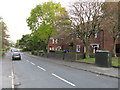
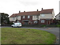
2
Daventry Road
One of the main access roads to the Kirkholt estate.
Image: © Bill Boaden
Taken: 2 Sep 2010
0.07 miles
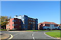
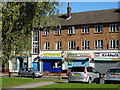
3
Shops on The Strand, Kirkholt
Kirkholt is an estate which appears in the local press often for the wrong reasons. Consequently the mix of shops has greater community emphasis.
Image: © Bill Boaden
Taken: 2 Sep 2010
0.09 miles
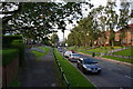
4
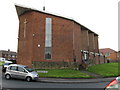
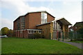
Kirkholt - RC Church, Gainsborough Drive
Image: © Peter Whatley
Taken: 5 Oct 2009
0.11 miles
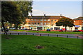
7
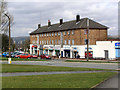
The Strand, Kirkholt
Row of shops on The Strand, Kirkholt
Image: © David Dixon
Taken: 25 Mar 2010
0.13 miles
9

Kirkholt Post Office
The Strand, Kirkholt.
Image: © David Dixon
Taken: 25 Mar 2010
0.14 miles