IMAGES TAKEN NEAR TO
Queens Drive, ROCHDALE, OL11 2NW
Introduction
This page details the photographs taken nearby to Queens Drive, OL11 2NW by members of the Geograph project.
The Geograph project started in 2005 with the aim of publishing, organising and preserving representative images for every square kilometre of Great Britain, Ireland and the Isle of Man.

There are currently over 7.5m images from over14,400 individuals and you can help contribute to the project by visiting https://www.geograph.org.uk
Image Map
Images are licensed for reuse under creativecommons.org/licenses/by-sa/2.0
Notes
- Clicking on the map will re-center to the selected point.
- The higher the marker number, the further away the image location is from the centre of the postcode.
Image Listing (27 Images Found)
Images are licensed for reuse under creativecommons.org/licenses/by-sa/2.0
Image
Details
Distance
1
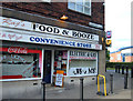
Food and Booze
Convenience store protected by anti ram-raiding bollards at Queens Drive Shops, Queens Drive on the Kirkholt estate.
Image: © michael ely
Taken: 11 Aug 2007
0.09 miles
2
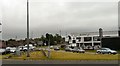
Edinburgh Way
The A664 linking the end of the A627(M) to Queensway.
Image: © Gerald England
Taken: 10 Jun 2010
0.11 miles
3
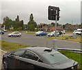
Edinburgh Way
The A627(M) ends at a T-junction with Edinburgh Way.
Image: © Gerald England
Taken: 10 Jun 2010
0.11 miles
4
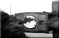
Gorell's Bridge, Rochdale Canal, Lancashire
When this photograph was taken, the Rochdale Canal had already been closed to navigation for some years, and it appeared that all hope of navigation ever being restored had been extinguished, when the whole area, including this bridge, was flattened with new road and motorway construction in the mid 1960s. However, a miracle happened, and a way for the canal was found through the new construction, and navigation was restored in 2003, (see Martin Clark's excellent picture).
Image: © Dr Neil Clifton
Taken: 3 Jun 1950
0.11 miles
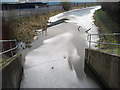
6

New Tunnel, Rochdale Canal
This is the western end of the tunnel. See Image
Image: © Dr Neil Clifton
Taken: 4 Jul 2003
0.13 miles
7
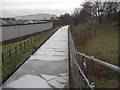
Rochdale Canal Gorrells Way
Looking towards Rochdale from the bridge on Gorrells Way. The A627(M) is on the right - motorway sign just visible through the trees.
Image: © michael ely
Taken: 19 Jan 2010
0.13 miles
8
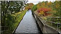
Rochdale Canal Deviation
To re-open the Rochdale Canal a deviation was required around the A627(M) motorway and the A664 Edinburgh Way. This is the view of the new stretch from the Gorrels Way bridge
Image: © Kevin Waterhouse
Taken: 25 Oct 2020
0.13 miles
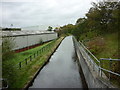
9
Rochdale Canal Gorrells Way
The towpath starts again (right of shot) after a short detour where the canal passes beneath the A627(M) motorway.
Image: © michael ely
Taken: 19 Jan 2010
0.14 miles
10
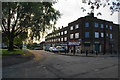
Queens Drive Shops
All the flats above are boarded up and some of the shops are empty.
Image: © Bill Boaden
Taken: 2 Sep 2010
0.15 miles