IMAGES TAKEN NEAR TO
Queens Drive, ROCHDALE, OL11 2NP
Introduction
This page details the photographs taken nearby to Queens Drive, OL11 2NP by members of the Geograph project.
The Geograph project started in 2005 with the aim of publishing, organising and preserving representative images for every square kilometre of Great Britain, Ireland and the Isle of Man.

There are currently over 7.5m images from over14,400 individuals and you can help contribute to the project by visiting https://www.geograph.org.uk
Image Map
Images are licensed for reuse under creativecommons.org/licenses/by-sa/2.0
Notes
- Clicking on the map will re-center to the selected point.
- The higher the marker number, the further away the image location is from the centre of the postcode.
Image Listing (36 Images Found)
Images are licensed for reuse under creativecommons.org/licenses/by-sa/2.0
Image
Details
Distance
1
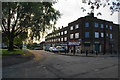
Queens Drive Shops
All the flats above are boarded up and some of the shops are empty.
Image: © Bill Boaden
Taken: 2 Sep 2010
0.02 miles
2
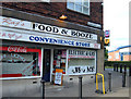
Food and Booze
Convenience store protected by anti ram-raiding bollards at Queens Drive Shops, Queens Drive on the Kirkholt estate.
Image: © michael ely
Taken: 11 Aug 2007
0.04 miles
3
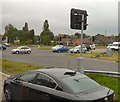
Edinburgh Way
The A627(M) ends at a T-junction with Edinburgh Way.
Image: © Gerald England
Taken: 10 Jun 2010
0.13 miles
4
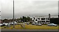
Edinburgh Way
The A664 linking the end of the A627(M) to Queensway.
Image: © Gerald England
Taken: 10 Jun 2010
0.13 miles
5
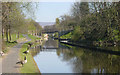
Rochdale Canal, Edinburgh Way, Rochdale
The restored Rochdale Canal, looking north-east from Edinburgh Way. The two bridges in the picture were re-built as part of the restoration.
Image: © Martin Clark
Taken: Unknown
0.14 miles
6

New Tunnel, Rochdale Canal
This is the eastern end of the tunnel built underneath the motorway approaches. There is no towpath through the tunnel, and it is difficult, tedious and dangerous picking your way across to find the continuation of the towpath at the other end. This is a point which needs addressing urgently, Canal Society please note!
Image: © Dr Neil Clifton
Taken: 17 Jun 2008
0.15 miles
8
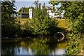
Rochdale Canal at Sandbrook Park
Looking west from bridge#62a, Hartley Lane Bridge. The canal was culverted here until restoration work reopened it. The building on the right, behind the towpath is "The Sandbrook", a carvery restaurant on the Sandbrook Park retail development (Image]).
Image: © David Dixon
Taken: 12 Oct 2012
0.15 miles
9
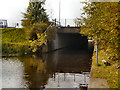
Rochdale Canal, Bridge 62b (Edinburgh Way Tunnel)
New tunnel/bridge created when the canal was reopened in the early 2000s.
Edinburgh Way was built partly over the line of the canal so it was necessary to divert it along a new line for the next quarter of a mile. The original canal line was to the left. See http://www.penninewaterways.co.uk/rochdale/rc55.htm photos of construction work.
Image: © David Dixon
Taken: 12 Oct 2012
0.16 miles
