IMAGES TAKEN NEAR TO
Greenfield Street, ROCHDALE, OL11 2JX
Introduction
This page details the photographs taken nearby to Greenfield Street, OL11 2JX by members of the Geograph project.
The Geograph project started in 2005 with the aim of publishing, organising and preserving representative images for every square kilometre of Great Britain, Ireland and the Isle of Man.

There are currently over 7.5m images from over14,400 individuals and you can help contribute to the project by visiting https://www.geograph.org.uk
Image Map
Images are licensed for reuse under creativecommons.org/licenses/by-sa/2.0
Notes
- Clicking on the map will re-center to the selected point.
- The higher the marker number, the further away the image location is from the centre of the postcode.
Image Listing (49 Images Found)
Images are licensed for reuse under creativecommons.org/licenses/by-sa/2.0
Image
Details
Distance
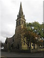
6
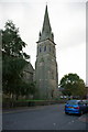
Parish Church of St Mary, Balderstone
Image: © Alexander P Kapp
Taken: 17 Oct 2005
0.07 miles
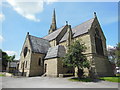
7
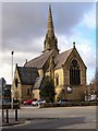
St Mary's Parish Church, Balderstone
Oldham Road.
Image: © David Dixon
Taken: 1 Mar 2010
0.08 miles
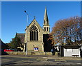
8
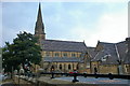
Parish Church of St Mary, Balderstone
Image: © Alexander P Kapp
Taken: 17 Oct 2005
0.08 miles
9
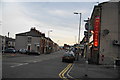
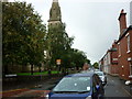
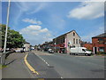
Oldham Road, Rochdale
Taken from just opposite St Mary's Church, Balderstone.
Image: © Bill Boaden
Taken: 6 Sep 2010
0.09 miles
10
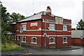
The 'Bridge Inn', Rochdale
Technically speaking this four-square pub of solid Accrington brick stands at the extreme southern end of Well i' th' Lane: its name comes from the bridge over Sudden Brook immediately south of the pub, and it is this bridge that marks the transition between Well i' th' Lane to the north, and Platting Lane to the south. Both of these are very old roads and part of the earliest route from Rochdale to Oldham, before the modern Oldham road was cut. The coming of the bypass in the form of Queensway and, later, Kingsway, altered the geography of the area substantially, and the bit south of Queensway seemed to lose identity as part of Well i' th' Lane.
Image: © Dr Neil Clifton
Taken: 9 Jul 2007
0.09 miles