IMAGES TAKEN NEAR TO
Everest Street, ROCHDALE, OL11 2DZ
Introduction
This page details the photographs taken nearby to Everest Street, OL11 2DZ by members of the Geograph project.
The Geograph project started in 2005 with the aim of publishing, organising and preserving representative images for every square kilometre of Great Britain, Ireland and the Isle of Man.

There are currently over 7.5m images from over14,400 individuals and you can help contribute to the project by visiting https://www.geograph.org.uk
Image Map
Images are licensed for reuse under creativecommons.org/licenses/by-sa/2.0
Notes
- Clicking on the map will re-center to the selected point.
- The higher the marker number, the further away the image location is from the centre of the postcode.
Image Listing (9 Images Found)
Images are licensed for reuse under creativecommons.org/licenses/by-sa/2.0
Image
Details
Distance
1
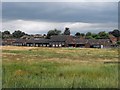
Hill Top School, Kirkholt (Waterloo Road)
Viewed from the footbridge, at Kirkholt, across the M62 the closed Hill Top School has not yet been completedly abandoned. In the foreground are the old sports fields with a goalpost still standing. The school buildings in the background are currently used by the BBC as a location for the school drama 'Waterloo Road'.
Image: © Peter Thwaite
Taken: 14 Jul 2010
0.12 miles
2
Hill Top School, Kirkholt
Viewed from Hill Top Drive the closed Hill Top School appears unusually busy. The television/film equipment is part of the presence of the BBC who currently use the school as a film set for the school drama 'Waterloo Road'.
Image: © Peter Thwaite
Taken: 14 Jul 2010
0.15 miles
4
Hill Top School, Kirkholt
Viewed from Hill Top Drive the gate to Hill Top School is closed as indeed is the school itself. The school buildings are currently used by the BBC as a film set for the school drama 'Waterloo Road'.
Image: © Peter Thwaite
Taken: 14 Jul 2010
0.18 miles
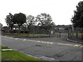
5
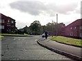
Kirkholt - Great Gates Road
Part of the "dodgy" Kirkholt estate. Not a place to hang about with a camera.
Image: © Peter Whatley
Taken: 5 Oct 2009
0.20 miles
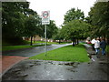
7
Kirkholt: Arkwright Way
The large Kirkholt Estate was Rochdale Corporation's answer to the post-WWII housing crisis. Much of the estate was built by direct labour, and it must be said that this estate has stood the test of time very well. Many of the houses are now in private hands, and all are well kept. The estate is pleasant and open, with very few, if any, of the 'tinned-up' houses often found on large council estates elsewhere.
Image: © Dr Neil Clifton
Taken: 8 Sep 2012
0.22 miles

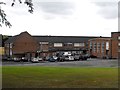
9
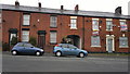
456 to 452 Oldham Road, Rochdale
From left to right are numbers 456 to 452 Oldham Road, which are terraced properties lining the A671 in the Balderstone area of Rochdale, Greater Manchester, England. Such red-brick properties are common throughout both Rochdale and Greater Manchester. Number 452 Oldham Road is boarded up in this photograph - it was formerly the Royal Hotel, a public house which has clearly closed for business.
Image: © Steven Haslington
Taken: 17 May 2012
0.24 miles