IMAGES TAKEN NEAR TO
Philip Street, ROCHDALE, OL11 1PJ
Introduction
This page details the photographs taken nearby to Philip Street, OL11 1PJ by members of the Geograph project.
The Geograph project started in 2005 with the aim of publishing, organising and preserving representative images for every square kilometre of Great Britain, Ireland and the Isle of Man.

There are currently over 7.5m images from over14,400 individuals and you can help contribute to the project by visiting https://www.geograph.org.uk
Image Map
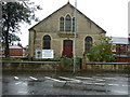
Images are licensed for reuse under creativecommons.org/licenses/by-sa/2.0
Notes
- Clicking on the map will re-center to the selected point.
- The higher the marker number, the further away the image location is from the centre of the postcode.
Image Listing (153 Images Found)
Images are licensed for reuse under creativecommons.org/licenses/by-sa/2.0
Image
Details
Distance
1
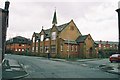
Zion Baptist Church, Milkstone Road, Rochdale
Image: © Ian S
Taken: 11 Sep 2010
0.04 miles
5
St. Luke's Church, Salkeld Street, Deeplish, Rochdale, Lancashire
This building was formerly the Sunday School of St. Luke's: the actual Church building stood a short distance further away from the photographer, on Deeplish Road. But in the 1980s the large Church itself was sold for demolition and replaced by the modern flats visible in the left background of the photograph. Services were then transferred to the Sunday School building shown above, which thus became the Church.
Image: © Dr Neil Clifton
Taken: 22 Mar 2004
0.10 miles
6
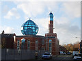
Mosque, Durham Street, Rochdale
A striking piece of Islamic architecture near Rochdale's railway station. Situated on the corner of Durham Street and Hare Street.
Image: © michael ely
Taken: 28 Nov 2006
0.10 miles
7
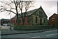
Baptist Church, Overt Street, Deeplish, Rochdale Lancashire.
Unlike many smaller nonconformist churches, which have 'gone under', this one is still holding its own in an area mainly occupied by people of New Commonwealth origin.
Image: © Dr Neil Clifton
Taken: 22 Mar 2004
0.10 miles
8
Well i' th' Lane, Rochdale: looking north
The photographer stands slightly south of the 'Horse and Jockey', facing northwards to the canal bridge which marks the northern end of Well i' th' Lane.
Image: © Dr Neil Clifton
Taken: 9 Jul 2007
0.13 miles
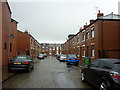
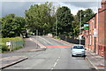
9
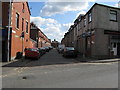
Rochdale: Maldon Street
Seen from its junction with Milkstone Road. Most Victorian terrace houses still survive on this street.
Image: © Dr Neil Clifton
Taken: 18 Mar 2011
0.13 miles
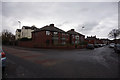
10
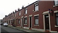
Aubrey Street, Rochdale
A row of red-brick terraced houses on Aubrey Street in Rochdale, Greater Manchester, England. Such housing stock is typical of much of Rochdale and of Greater Manchester.
Image: © Steven Haslington
Taken: 11 Nov 2011
0.13 miles