IMAGES TAKEN NEAR TO
Clifford Street, ROCHDALE, OL11 1NG
Introduction
This page details the photographs taken nearby to Clifford Street, OL11 1NG by members of the Geograph project.
The Geograph project started in 2005 with the aim of publishing, organising and preserving representative images for every square kilometre of Great Britain, Ireland and the Isle of Man.

There are currently over 7.5m images from over14,400 individuals and you can help contribute to the project by visiting https://www.geograph.org.uk
Image Map
Images are licensed for reuse under creativecommons.org/licenses/by-sa/2.0
Notes
- Clicking on the map will re-center to the selected point.
- The higher the marker number, the further away the image location is from the centre of the postcode.
Image Listing (74 Images Found)
Images are licensed for reuse under creativecommons.org/licenses/by-sa/2.0
Image
Details
Distance
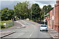
1
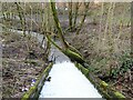
Sudden Brook
The overspill from the Rochdale Canal discharges into Sudden Brook, a tributary of the River Roch.
Image: © michael ely
Taken: 13 Mar 2021
0.05 miles

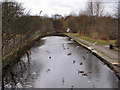
3
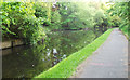
Rochdale Canal
Looking towards Castleton from just past where Sudden Brook meets the canal.
Image: © michael ely
Taken: 15 May 2014
0.08 miles
4
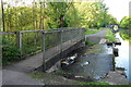
Spillway on the Rochdale Canal
Here the water from the canal runs into Sudden Brook.
Image: © michael ely
Taken: 15 May 2014
0.08 miles
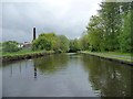
5
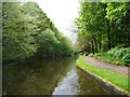
Rochdale Canal, between bridges 61 and 62
Seen from the front of a narrowboat heading south-west towards Manchester.
Image: © Christine Johnstone
Taken: 7 May 2014
0.09 miles
6
Well i' th' Lane, Rochdale: looking north
The photographer stands slightly south of the 'Horse and Jockey', facing northwards to the canal bridge which marks the northern end of Well i' th' Lane.
Image: © Dr Neil Clifton
Taken: 9 Jul 2007
0.09 miles
7
Rochdale Canal
Looking towards the South-west from Well i'th' Lane.
Image: © David Dixon
Taken: 15 Mar 2010
0.09 miles
8
Rochdale Canal, south-west of Bridge 61
Seen from the front of a narrowboat heading south-west towards Manchester.
Image: © Christine Johnstone
Taken: 7 May 2014
0.09 miles
9
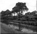
Rochdale Canal
The houses visible in the background were then in local authority ownership: those on the right in Digby Road, and those on the extreme left in Dicken Green.
Although the water looks clear, the Rochdale Canal was not navigable at that time.
Image: © Dr Neil Clifton
Taken: 3 Sep 1954
0.10 miles
10
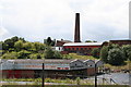
Dicken Green Mill, Rochdale, Lancashire
Demolition of Well i' th' Lane Mill Image has left open this view towards Dicken Green Mill, once a cotton mill, but no doubt now finding other uses.
Image: © Dr Neil Clifton
Taken: 9 Jul 2007
0.12 miles