IMAGES TAKEN NEAR TO
Pioneer Street, ROCHDALE, OL11 1JG
Introduction
This page details the photographs taken nearby to Pioneer Street, OL11 1JG by members of the Geograph project.
The Geograph project started in 2005 with the aim of publishing, organising and preserving representative images for every square kilometre of Great Britain, Ireland and the Isle of Man.

There are currently over 7.5m images from over14,400 individuals and you can help contribute to the project by visiting https://www.geograph.org.uk
Image Map
Images are licensed for reuse under creativecommons.org/licenses/by-sa/2.0
Notes
- Clicking on the map will re-center to the selected point.
- The higher the marker number, the further away the image location is from the centre of the postcode.
Image Listing (261 Images Found)
Images are licensed for reuse under creativecommons.org/licenses/by-sa/2.0
Image
Details
Distance
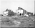
1

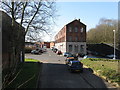
Colby Street (East side), Rochdale, Lancashire
During 1979, the demolition of a large area of terrace houses south east of Rochdale station was being progressed. This is - or was - Colby Street, with its T-junction with Hare Street just beyond the block under demolition, and Equitable Street further on.
Image: © Dr Neil Clifton
Taken: 24 Sep 2007
0.04 miles
2
Colby Street, Rochdale, Lancashire
Almost certainly the last photograph anyone took of this street!
Image: © Dr Neil Clifton
Taken: 15 Sep 1979
0.04 miles
3
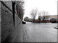
Miall Street, Rochdale
Miall Street runs parallel to the railway on the south side of Rochdale Station. Since Dr Neil Clifton's 1955 photograph http://www.geograph.org.uk/photo/192836 terraced housing has been cleared, the road metalled and cars have claimed the street.
Image: © Peter Thwaite
Taken: 4 Feb 2010
0.05 miles
4
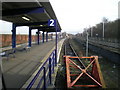
End of the line 2
Platform 2 Rochdale railway station.
Image: © R lee
Taken: 31 Jan 2009
0.06 miles
5
Rochdale: Durham Street
Seen from its junction with Miall Street,from where this long street runs right through to a junction with Oldham Road. A minaret of the new mosque built recently can just be seen.
Image: © Dr Neil Clifton
Taken: 18 Mar 2011
0.06 miles
6
Rochdale: Former Ormerod's Leather Works, Miall Street
Image: © Dr Neil Clifton
Taken: 18 Mar 2011
0.06 miles
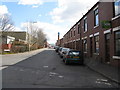
7
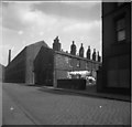
Miall Street, Rochdale, Lancashire
Another view of this gloomy street behind Rochdale station. The large factory ahead is Ormerod's Leather Works, while Landseer Street, complete with washing, branches off to the right.
Image: © Dr Neil Clifton
Taken: 15 Apr 1955
0.07 miles
8
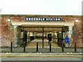
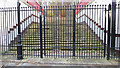
Rochdale station - southern entrance
The entrance from Miall Street was disused for a long time, and still so in 2011 Image but has been reopened with a retro-style name plate.
Image: © Stephen Craven
Taken: 26 Nov 2018
0.07 miles
9
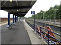
Rochdale Station - Oldham Bay Platform
End of the line for Manchester-Oldham-Rochdale services, platform 2 will have no useful function after October 3rd 2009 when the service ceases.
Image: © Peter Whatley
Taken: 16 Sep 2009
0.08 miles
10
Steps to disused platforms, Rochdale station
Rochdale station was once a significant interchange with up to eight platforms. Neil Clifton gives a fuller history of these disused platforms here: Image
Image: © Stephen Craven
Taken: 26 Nov 2018
0.08 miles