IMAGES TAKEN NEAR TO
William Street, ROCHDALE, OL11 1HW
Introduction
This page details the photographs taken nearby to William Street, OL11 1HW by members of the Geograph project.
The Geograph project started in 2005 with the aim of publishing, organising and preserving representative images for every square kilometre of Great Britain, Ireland and the Isle of Man.

There are currently over 7.5m images from over14,400 individuals and you can help contribute to the project by visiting https://www.geograph.org.uk
Image Map
Images are licensed for reuse under creativecommons.org/licenses/by-sa/2.0
Notes
- Clicking on the map will re-center to the selected point.
- The higher the marker number, the further away the image location is from the centre of the postcode.
Image Listing (221 Images Found)
Images are licensed for reuse under creativecommons.org/licenses/by-sa/2.0
Image
Details
Distance
1
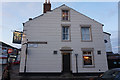
Rochdale: The 'Queens', Tweedale Street
When I first photographed the 'Queens', I got a First Geograph point for it. The 'Queens' was then still open. There are now some 90 images for this gridsquare, and the pub. is closed, probably permanently.
Image: © Dr Neil Clifton
Taken: 18 Mar 2011
0.06 miles
2
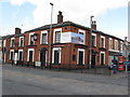
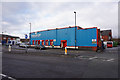
Rochdale: The 'Corporation Inn', Lower Tweedale Street
Like the 'Queens' across the other side of Milkstone Road, the 'Corporation' is closed, almost certainly permanently. Within this grid square, five public houses have now closed since Geograph began: only the 'Weavers Arms' on Ashfield Road still soldiers on. For reference the closures are: 'Navigation', 'Woolpack', 'Queens', 'Commercial', and 'Brown Cow'. This is really getting to crisis proportions!
Image: © Dr Neil Clifton
Taken: 18 Mar 2011
0.06 miles
4
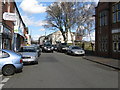
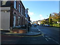
Rochdale: Milkstone Road
Looking north. Milkstone Road formed part of the ancient route from Rochdale to Oldham.
Image: © Dr Neil Clifton
Taken: 18 Mar 2011
0.08 miles
5
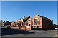
Former Castlemere Board School
Now Castlemere Community Centre.
Image: © JThomas
Taken: 10 Oct 2018
0.10 miles
6
Junction of Milkstone Road and Drake Street
Image: © Raymond Knapman
Taken: 4 Nov 2013
0.10 miles
7

Castlemere Community Centre
On Tweedale Street the former Castlemere Board School 1893 is now a community centre http://www.castlemere.org.uk/.
On the left, in the background, is the minaret of the Castlemere Mosque.
Image: © Peter Thwaite
Taken: 21 Apr 2010
0.10 miles
8
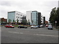
Rochdale - Nye Bevan House
An NHS facility set back from Maclure Street.
Image: © Peter Whatley
Taken: 16 Sep 2009
0.10 miles
10
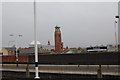
Rochdale rooftops
Viewed from Rochdale Railway Station.
Image: © SMJ
Taken: 23 Apr 2009
0.10 miles