IMAGES TAKEN NEAR TO
Lower Tweedale Street, ROCHDALE, OL11 1HG
Introduction
This page details the photographs taken nearby to Lower Tweedale Street, OL11 1HG by members of the Geograph project.
The Geograph project started in 2005 with the aim of publishing, organising and preserving representative images for every square kilometre of Great Britain, Ireland and the Isle of Man.

There are currently over 7.5m images from over14,400 individuals and you can help contribute to the project by visiting https://www.geograph.org.uk
Image Map
Images are licensed for reuse under creativecommons.org/licenses/by-sa/2.0
Notes
- Clicking on the map will re-center to the selected point.
- The higher the marker number, the further away the image location is from the centre of the postcode.
Image Listing (231 Images Found)
Images are licensed for reuse under creativecommons.org/licenses/by-sa/2.0
Image
Details
Distance
2
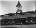
Rochdale Railway Station
Looking from Tweedale Street. A train is waiting on one of the platforms and many white taxis are waiting outside.
Image: © michael ely
Taken: 28 Nov 2006
0.03 miles
3
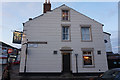
Rochdale: The 'Corporation Inn', Lower Tweedale Street
Like the 'Queens' across the other side of Milkstone Road, the 'Corporation' is closed, almost certainly permanently. Within this grid square, five public houses have now closed since Geograph began: only the 'Weavers Arms' on Ashfield Road still soldiers on. For reference the closures are: 'Navigation', 'Woolpack', 'Queens', 'Commercial', and 'Brown Cow'. This is really getting to crisis proportions!
Image: © Dr Neil Clifton
Taken: 18 Mar 2011
0.03 miles
5
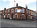
Rochdale: The 'Queens', Tweedale Street
When I first photographed the 'Queens', I got a First Geograph point for it. The 'Queens' was then still open. There are now some 90 images for this gridsquare, and the pub. is closed, probably permanently.
Image: © Dr Neil Clifton
Taken: 18 Mar 2011
0.04 miles
7
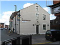
Rochdale - Nye Bevan House
An NHS facility set back from Maclure Street.
Image: © Peter Whatley
Taken: 16 Sep 2009
0.04 miles
8
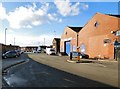
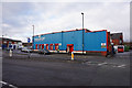
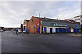
Haji Cash and Carry
Haji Food Store started in 1955 by two brothers from a small shop on Tweedale Street in Rochdale. The shop catered mostly to the Asian section of what was known as the North's Little Pakistan. It has since grown to become Haji Cash & Carry, operating from a wholesale and corporate 8000 sq feet Headquarters located on Station Approach, Lower Tweedale Street. http://web.archive.org/web/20161122204137/http://www.haji.co.uk/haji-cash-carry
Note: Photograph is for record purposes only. The photographer has no connection with the business depicted.
Image: © Gerald England
Taken: 4 Feb 2017
0.04 miles
9
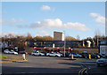
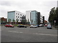
Rochdale: View along Station Road
Looking north east from Milkstone Road. The yard to the right, where motor cars are now parked, was a railway yard serving two sidings off the Down loop line. The shorter siding was for fish traffic, which arrived very early each morning: one porter had the specific task of looking after this; The longer siding was for livestock traffic, which did not see much use after about 1952, but in the 1940s there was the sad sight of fine young Irish horses being unloaded there, before being roped together and walked down via Milkstone Road and Church Stile to the abattoir in Brickcroft near the town centre. The trade in horsemeat in Rochdale was in Britain second only to that at Acton, in West London.
Image: © Dr Neil Clifton
Taken: 18 Mar 2011
0.06 miles