IMAGES TAKEN NEAR TO
Summit Street, HEYWOOD, OL10 4RH
Introduction
This page details the photographs taken nearby to Summit Street, OL10 4RH by members of the Geograph project.
The Geograph project started in 2005 with the aim of publishing, organising and preserving representative images for every square kilometre of Great Britain, Ireland and the Isle of Man.

There are currently over 7.5m images from over14,400 individuals and you can help contribute to the project by visiting https://www.geograph.org.uk
Image Map
Images are licensed for reuse under creativecommons.org/licenses/by-sa/2.0
Notes
- Clicking on the map will re-center to the selected point.
- The higher the marker number, the further away the image location is from the centre of the postcode.
Image Listing (8 Images Found)
Images are licensed for reuse under creativecommons.org/licenses/by-sa/2.0
Image
Details
Distance
1
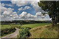
View towards Ashworth Moor
View towards Ashworth Moor
Image: © Galatas
Taken: 29 Jul 2008
0.02 miles
2
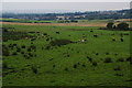
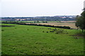
Cows in the Roch valley
Looking in the direction of northern Bury from Summit Street.
Image: © Bill Boaden
Taken: 26 Jul 2012
0.08 miles
3
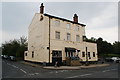
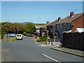
The Summit Hotel
Situated at the highest point on the A58 between Heywood and Bury.
Image: © Bill Boaden
Taken: 26 Jul 2012
0.09 miles
5
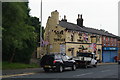
Hark to Towler, Heady Hill
There have been a lot of reasons this year for decoration such as this, but one recent reason was Armed Forces day on 30th June 2012 for which there is still a large flag.
Image: © Bill Boaden
Taken: 26 Jul 2012
0.12 miles
6
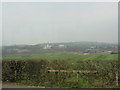
The Roch valley from Bury New Road
The complex of buildings in the distance is Fairfield hospital.
Image: © Peter Whatley
Taken: 25 Mar 2011
0.20 miles
8
The Roch valley
Just above Bury. On the other side to the right is Fairfield Hospital. It is a grey day, and Holcombe Moor would normally be more clearly visible in the centre background.
Image: © Bill Boaden
Taken: 26 Jul 2012
0.23 miles