IMAGES TAKEN NEAR TO
Sandiway, HEYWOOD, OL10 4BY
Introduction
This page details the photographs taken nearby to Sandiway, OL10 4BY by members of the Geograph project.
The Geograph project started in 2005 with the aim of publishing, organising and preserving representative images for every square kilometre of Great Britain, Ireland and the Isle of Man.

There are currently over 7.5m images from over14,400 individuals and you can help contribute to the project by visiting https://www.geograph.org.uk
Image Map (Loading...)


Getting Data...Please wait
Leaflet Map data © OpenStreetMap
Images are licensed for reuse under creativecommons.org/licenses/by-sa/2.0
Notes
- Clicking on the map will re-center to the selected point.
- The higher the marker number, the further away the image location is from the centre of the postcode.
Image Listing (116 Images Found)
Images are licensed for reuse under creativecommons.org/licenses/by-sa/2.0
Image
Details
Distance
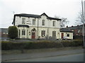
4
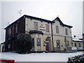
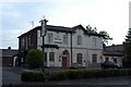
Albany hotel
View of Albany Hotel from the road
Image: © R lee
Taken: 2 Jan 2010
0.06 miles
5
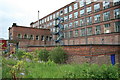
Mutual Mills - No. 3 mill
No. 3 engine house. This is the engine house visible in the sunset over Mutual Mills shots.
Image: © Chris Allen
Taken: 27 May 2007
0.07 miles
7
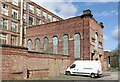
Mutual Mills, Heywood ? 19
Engine house, Mill No.3. To the left is the boiler house.
Image: © Alan Murray-Rust
Taken: 8 Apr 2022
0.08 miles