IMAGES TAKEN NEAR TO
Alte Volo Close, OL10 4AY
Introduction
This page details the photographs taken nearby to Alte Volo Close, OL10 4AY by members of the Geograph project.
The Geograph project started in 2005 with the aim of publishing, organising and preserving representative images for every square kilometre of Great Britain, Ireland and the Isle of Man.

There are currently over 7.5m images from over14,400 individuals and you can help contribute to the project by visiting https://www.geograph.org.uk
Image Map (Loading...)


Getting Data...Please wait
Leaflet Map data © OpenStreetMap
Images are licensed for reuse under creativecommons.org/licenses/by-sa/2.0
Notes
- Clicking on the map will re-center to the selected point.
- The higher the marker number, the further away the image location is from the centre of the postcode.
Image Listing (32 Images Found)
Images are licensed for reuse under creativecommons.org/licenses/by-sa/2.0
Image
Details
Distance
1
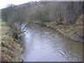
River Roch
Facing North East from the bridge at Bottom O' th' Brow
Image: © Paul Hogg
Taken: 19 Jan 2008
0.15 miles
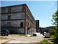
3

Hooley Bridge Mill
End of an era after christmas fire.
Image: © ANDY RAMMY
Taken: 1 Jan 2007
0.16 miles

5
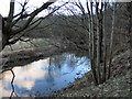
River Roch
A stretch of the River Roch below Bottom'o'th'Brow and the disused workings along the bank.
Image: © Roger May
Taken: 28 Feb 2006
0.18 miles
6
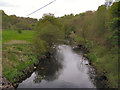
River Roch
Looking upstream from the bridge at Bottom O'Th' Brow.
Image: © David Dixon
Taken: 7 May 2010
0.19 miles
7
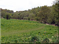
Roch Valley
Looking towards Gristlehurst Wood from Roch Valley at Bottom O'Th' Brow, Heywood.
Image: © David Dixon
Taken: 7 May 2010
0.19 miles

9

Hooley Bridge: Possibly former public house
Image: © Dr Neil Clifton
Taken: 4 Jun 2013
0.20 miles
10
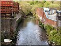
River Roch
Looking downstream from Hooley Bridge.
Image: © David Dixon
Taken: 4 May 2010
0.20 miles