IMAGES TAKEN NEAR TO
Heys Lane, HEYWOOD, OL10 3RA
Introduction
This page details the photographs taken nearby to Heys Lane, OL10 3RA by members of the Geograph project.
The Geograph project started in 2005 with the aim of publishing, organising and preserving representative images for every square kilometre of Great Britain, Ireland and the Isle of Man.

There are currently over 7.5m images from over14,400 individuals and you can help contribute to the project by visiting https://www.geograph.org.uk
Image Map (Loading...)


Getting Data...Please wait
Leaflet Map data © OpenStreetMap
Images are licensed for reuse under creativecommons.org/licenses/by-sa/2.0
Notes
- Clicking on the map will re-center to the selected point.
- The higher the marker number, the further away the image location is from the centre of the postcode.
Image Listing (8 Images Found)
Images are licensed for reuse under creativecommons.org/licenses/by-sa/2.0
Image
Details
Distance
1
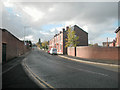
Towards Heady Hill
View from Wham Bar along the old road from Heywood to Bury. The wall on the left is from the remains of a former textile mill.
Image: © Dennis Turner
Taken: 9 Nov 2005
0.11 miles
2
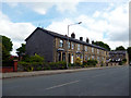
Heywood: Nos. 148 to 160, Bury Old Road
Solid, roomy and well-built stone terrace houses
Image: © Dr Neil Clifton
Taken: 2 Jun 2013
0.15 miles
3
Wham Bar
Road junction between Heywood and Bury. View towards Summit of Prettywood Brow, on Bury New Road.
Image: © Dennis Turner
Taken: 9 Nov 2005
0.16 miles
4
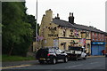
Hark to Towler, Heady Hill
There have been a lot of reasons this year for decoration such as this, but one recent reason was Armed Forces day on 30th June 2012 for which there is still a large flag.
Image: © Bill Boaden
Taken: 26 Jul 2012
0.20 miles
5

Wham Street
At the junction with Bury Street, Heywood. The Horse and Jockey public house is only one of many such establishments along this road to supply refreshment for the carters before or after the climb to Prettywood summit.
Image: © Dennis Turner
Taken: 9 Nov 2005
0.22 miles
6
Bury Old Road. Heywood
Superseded by Bury New Road, the A58, which is more direct.
Image: © Bill Boaden
Taken: 26 Jul 2012
0.23 miles
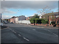
7

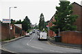
Approaching the centre of Heywood
The A58 runs through the town. The spire in the distance is that of St. Luke's church, a Church of England parish church.
Image: © philandju
Taken: 7 Aug 2017
0.24 miles
8
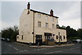
The Summit Hotel
Situated at the highest point on the A58 between Heywood and Bury.
Image: © Bill Boaden
Taken: 26 Jul 2012
0.24 miles