IMAGES TAKEN NEAR TO
Girvan Walk, HEYWOOD, OL10 3PT
Introduction
This page details the photographs taken nearby to Girvan Walk, OL10 3PT by members of the Geograph project.
The Geograph project started in 2005 with the aim of publishing, organising and preserving representative images for every square kilometre of Great Britain, Ireland and the Isle of Man.

There are currently over 7.5m images from over14,400 individuals and you can help contribute to the project by visiting https://www.geograph.org.uk
Image Map
Images are licensed for reuse under creativecommons.org/licenses/by-sa/2.0
Notes
- Clicking on the map will re-center to the selected point.
- The higher the marker number, the further away the image location is from the centre of the postcode.
Image Listing (28 Images Found)
Images are licensed for reuse under creativecommons.org/licenses/by-sa/2.0
Image
Details
Distance
2
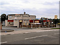
The Highlander
Sutherland Road, Darnhill.
Image: © David Dixon
Taken: 19 Jul 2010
0.12 miles
3
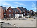
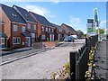
Building Work at Former Site of Heywood Community School
Sutherland High School, on Sutherland Road at Darnhill, was opened in 1966. Its name was changed to Heywood Community School in the 1990s.
Closed in June 2010 (http://menmedia.co.uk/heywoodadvertiser/news/s/1193762_school_party_to_mark_the_end_of_an_era - Heywood Advertiser and http://news.bbc.co.uk/local/manchester/hi/people_and_places/newsid_8940000/8940501.stm - BBC Education), it was demolished during the winter of 2010-11 and by 2014, a development of new houses was being built. There is now little or no evidence to show that the school buildings once stood on this site.
Compare with Image], taken in 1977, Image], Image] and Image] taken in 2012.
Image: © David Dixon
Taken: 14 May 2014
0.12 miles
4
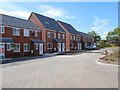
New Houses Being Built at Darnhill
Sutherland High School, on Sutherland Road at Darnhill, was opened in 1966. Its name was changed to Heywood Community School in the 1990s.
Closed in June 2010 (http://menmedia.co.uk/heywoodadvertiser/news/s/1193762_school_party_to_mark_the_end_of_an_era - Heywood Advertiser and http://news.bbc.co.uk/local/manchester/hi/people_and_places/newsid_8940000/8940501.stm - BBC Education), it was demolished during the winter of 2010-11 and by 2014, a development of new houses was being built. There is now little or no evidence to show that the school buildings once stood on this site.
Compare with Image], taken in 1977, Image], Image] and Image] taken in 2012.
Image: © David Dixon
Taken: 14 May 2014
0.12 miles
5
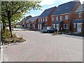
Sutherland Road, New Housing Development
Sutherland High School, on Sutherland Road at Darnhill, was opened in 1966. Its name was changed to Heywood Community School in the 1990s.
Closed in June 2010 (http://menmedia.co.uk/heywoodadvertiser/news/s/1193762_school_party_to_mark_the_end_of_an_era - Heywood Advertiser and http://news.bbc.co.uk/local/manchester/hi/people_and_places/newsid_8940000/8940501.stm - BBC Education), it was demolished during the winter of 2010-11 and by 2014, a development of new houses was being built. There is now little or no evidence to show that the school buildings once stood on this site.
Compare with Image], taken in 1977, Image], Image] and Image] taken in 2012.
Image: © David Dixon
Taken: 14 May 2014
0.12 miles
6
New Housing Development at Sutherland Road
Sutherland High School, on Sutherland Road at Darnhill, was opened in 1966. Its name was changed to Heywood Community School in the 1990s.
Closed in June 2010 (http://menmedia.co.uk/heywoodadvertiser/news/s/1193762_school_party_to_mark_the_end_of_an_era - Heywood Advertiser and http://news.bbc.co.uk/local/manchester/hi/people_and_places/newsid_8940000/8940501.stm - BBC Education), it was demolished during the winter of 2010-11 and by 2014, a development of new houses was being built. There is now little or no evidence to show that the school buildings once stood on this site.
Compare with Image], taken in 1977, Image], Image] and Image] taken in 2012.
Image: © David Dixon
Taken: 14 May 2014
0.14 miles
7
New Houses on Sutherland Road
Sutherland High School, on Sutherland Road at Darnhill, was opened in 1966. Its name was changed to Heywood Community School in the 1990s.
Closed in June 2010 (http://menmedia.co.uk/heywoodadvertiser/news/s/1193762_school_party_to_mark_the_end_of_an_era - Heywood Advertiser and http://news.bbc.co.uk/local/manchester/hi/people_and_places/newsid_8940000/8940501.stm - BBC Education), it was demolished during the winter of 2010-11 and by 2014, a development of new houses was being built. There is now little or no evidence to show that the school buildings once stood on this site.
Compare with Image], taken in 1977, Image], Image] and Image
Image: © David Dixon
Taken: 14 May 2014
0.16 miles
8
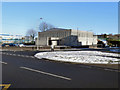
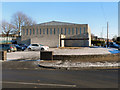
Our Lady & St Paul's RC Church, Darnhill
Our Lady & St Paul's RC church. At the corner of Sutherland Road and Argyle Street, Darnhill.
Image: © David Dixon
Taken: 8 Dec 2010
0.16 miles
9
Our Lady & St Paul's RC Church, Darnhill
Our Lady & St Paul's RC church. At the corner of Sutherland Road and Argyle Street, Darnhill.
Image: © David Dixon
Taken: 8 Dec 2010
0.16 miles
10
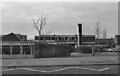
Sutherland High School
The high school, on Sutherland Road at Darnhill, was opened in 1966. Its name was changed to Heywood Community School in the 1990s. Closed in June 2010 (http://menmedia.co.uk/heywoodadvertiser/news/s/1193762_school_party_to_mark_the_end_of_an_era - Heywood Advertiser and http://news.bbc.co.uk/local/manchester/hi/people_and_places/newsid_8940000/8940501.stm - BBC Education), it was demolished during the winter of 2010-11.
This photograph was taken from in front of one of the high rise tower blocks (cf Image], taken from the top of the same block)
Image: © David Dixon
Taken: Unknown
0.16 miles