IMAGES TAKEN NEAR TO
Cromarty Square, HEYWOOD, OL10 3NN
Introduction
This page details the photographs taken nearby to Cromarty Square, OL10 3NN by members of the Geograph project.
The Geograph project started in 2005 with the aim of publishing, organising and preserving representative images for every square kilometre of Great Britain, Ireland and the Isle of Man.

There are currently over 7.5m images from over14,400 individuals and you can help contribute to the project by visiting https://www.geograph.org.uk
Image Map (Loading...)


Getting Data...Please wait
Leaflet Map data © OpenStreetMap
Images are licensed for reuse under creativecommons.org/licenses/by-sa/2.0
Notes
- Clicking on the map will re-center to the selected point.
- The higher the marker number, the further away the image location is from the centre of the postcode.
Image Listing (2 Images Found)
Images are licensed for reuse under creativecommons.org/licenses/by-sa/2.0
Image
Details
Distance
1
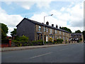
Heywood: Nos. 148 to 160, Bury Old Road
Solid, roomy and well-built stone terrace houses
Image: © Dr Neil Clifton
Taken: 2 Jun 2013
0.20 miles
2
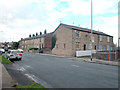
Top of Heap
Cottages on the old road between Heywood and Bury marking the summit of the climb from both towns. Ribbon housing development along the roads in this grid square up to WW2, since when there has been an increase in residential property. The four cottages to right of the picture are believed to have started life as a three storey hospital from the time of the Napoleonic wars. Converted to 8 back to back cottages in the 19th century and finally converted in the 1960s to four modern cottages.
Image: © Dennis Turner
Taken: 9 Nov 2005
0.21 miles