IMAGES TAKEN NEAR TO
Fustian Avenue, HEYWOOD, OL10 3FL
Introduction
This page details the photographs taken nearby to Fustian Avenue, OL10 3FL by members of the Geograph project.
The Geograph project started in 2005 with the aim of publishing, organising and preserving representative images for every square kilometre of Great Britain, Ireland and the Isle of Man.

There are currently over 7.5m images from over14,400 individuals and you can help contribute to the project by visiting https://www.geograph.org.uk
Image Map (Loading...)


Getting Data...Please wait
Leaflet Map data © OpenStreetMap
Images are licensed for reuse under creativecommons.org/licenses/by-sa/2.0
Notes
- Clicking on the map will re-center to the selected point.
- The higher the marker number, the further away the image location is from the centre of the postcode.
Image Listing (22 Images Found)
Images are licensed for reuse under creativecommons.org/licenses/by-sa/2.0
Image
Details
Distance
1
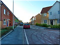
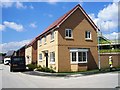
Fustain Avenue, Heywood
New development on the site of Unity Mill
Image: © Alexander P Kapp
Taken: 11 Dec 2012
0.01 miles
2

Last rites for the Unity Ring Mill, Heywood
The building shown is the engine house of the mill.
Image: © Dr Neil Clifton
Taken: 29 Jun 2008
0.04 miles
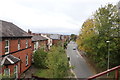
3
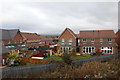
Housing development from the East Lancashire Railway
This is in the Broadfield area of Heywood. The buildings look relatively new.
Image: © Chris Allen
Taken: 20 Oct 2019
0.04 miles
4
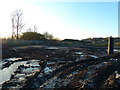
Muddy building site on the site of Unity Mill, Heywood
Image: © Alexander P Kapp
Taken: 11 Dec 2012
0.07 miles
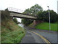
5
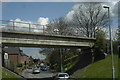
Bridge over Pilsworth Road
This bridge is part of the East Lancashire Railway.
Image: © R lee
Taken: 12 May 2010
0.10 miles
7
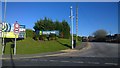
Broadfield Business Park
On the northwestern entrance of Broadfield Business Park, on Pilsworth Road in Heywood, Greater Manchester, England. This business park lies opposite Heywood Distribution Park, by the East Lancashire Railway.
Image: © Steven Haslington
Taken: 14 Apr 2015
0.11 miles
8
Railway bridge over Pilsworth Road, Heywood
Now used by the East Lancashire Railway (ELR).
Image: © JThomas
Taken: 17 Sep 2018
0.11 miles
9
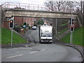
Pilsworth Road Railway Bridge
The railway bridge crossing over Pilsworth Road carries the East Lancashire Railway line between Heywood and Bury http://east-lancs-rly.co.uk/
This used to be a very low bridge restricting high vehicle access to the near by Heywood Distribution Park Image
The original bridge was demolished and rebuilt in 1993 when the railway line was reopened after being closed for 13 years.
Image: © Paul Anderson
Taken: 24 Nov 2008
0.11 miles
10
Pilsworth Road, Heywood
From the East Lancashire Railway
Image: © Chris Allen
Taken: 20 Oct 2019
0.12 miles