IMAGES TAKEN NEAR TO
Hendon Grove, HEYWOOD, OL10 2WJ
Introduction
This page details the photographs taken nearby to Hendon Grove, OL10 2WJ by members of the Geograph project.
The Geograph project started in 2005 with the aim of publishing, organising and preserving representative images for every square kilometre of Great Britain, Ireland and the Isle of Man.

There are currently over 7.5m images from over14,400 individuals and you can help contribute to the project by visiting https://www.geograph.org.uk
Image Map
Images are licensed for reuse under creativecommons.org/licenses/by-sa/2.0
Notes
- Clicking on the map will re-center to the selected point.
- The higher the marker number, the further away the image location is from the centre of the postcode.
Image Listing (23 Images Found)
Images are licensed for reuse under creativecommons.org/licenses/by-sa/2.0
Image
Details
Distance

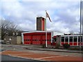
2

Heywood Community Fire Station
On Middleton Road.
Image: © JThomas
Taken: 25 Sep 2018
0.03 miles
5
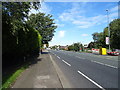
Middleton Road (A6046), Heywood
Looking north.
Image: © JThomas
Taken: 25 Sep 2018
0.04 miles
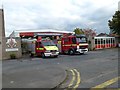
7

Fire Station.
Heywood Fire Station, Middleton Road, Heywood. SD86340929.
Image: © Keith Williamson
Taken: 20 Oct 2005
0.04 miles
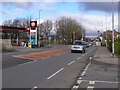
8
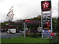
Filling Station.
Filling station on Middleton Road, Heywood. SD86330941.
Image: © Keith Williamson
Taken: 20 Oct 2005
0.06 miles
9
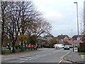
Junction of Coronation Avenue and Middleton Road
Seen from Arnold Avenue.
Image: © Christine Johnstone
Taken: 12 Nov 2010
0.07 miles
10

Service station on Middleton Road (A6046), Heywood
Image: © JThomas
Taken: 25 Sep 2018
0.08 miles