IMAGES TAKEN NEAR TO
NW6 5HJ
Introduction
This page details the photographs taken nearby to NW6 5HJ by members of the Geograph project.
The Geograph project started in 2005 with the aim of publishing, organising and preserving representative images for every square kilometre of Great Britain, Ireland and the Isle of Man.

There are currently over 7.5m images from over14,400 individuals and you can help contribute to the project by visiting https://www.geograph.org.uk
Image Map
Images are licensed for reuse under creativecommons.org/licenses/by-sa/2.0
Notes
- Clicking on the map will re-center to the selected point.
- The higher the marker number, the further away the image location is from the centre of the postcode.
Image Listing (346 Images Found)
Images are licensed for reuse under creativecommons.org/licenses/by-sa/2.0
Image
Details
Distance
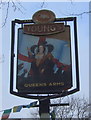
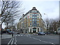
1
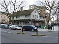
The Queens Arms public house
Kilburn High Rd, Maida Vale, London NW6.
Image: © JThomas
Taken: 18 Mar 2017
0.02 miles
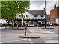
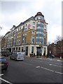
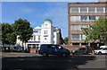
5
London Marriott Hotel Maida Vale
Plaza Parade, Maida Vale, London NW6 .
Image: © JThomas
Taken: 18 Mar 2017
0.03 miles
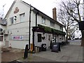
6
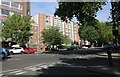
Maida Vale at the end of Kilburn Park Road
Image: © David Howard
Taken: 26 May 2020
0.03 miles
7
Kilburn Park Road at the junction of Maida Vale
Image: © David Howard
Taken: 3 Oct 2019
0.03 miles
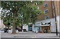
9
Kilburn Islamic Centre on Edgware Road
Image: © David Howard
Taken: 26 May 2020
0.04 miles
10

The Islamic Centre of England, 140 Maida Vale W9
Image: © Robin Sones
Taken: 26 Nov 2009
0.04 miles