IMAGES TAKEN NEAR TO
NW6 5HB
Introduction
This page details the photographs taken nearby to NW6 5HB by members of the Geograph project.
The Geograph project started in 2005 with the aim of publishing, organising and preserving representative images for every square kilometre of Great Britain, Ireland and the Isle of Man.

There are currently over 7.5m images from over14,400 individuals and you can help contribute to the project by visiting https://www.geograph.org.uk
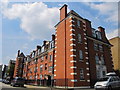
Image Map
Images are licensed for reuse under creativecommons.org/licenses/by-sa/2.0
Notes
- Clicking on the map will re-center to the selected point.
- The higher the marker number, the further away the image location is from the centre of the postcode.
Image Listing (82 Images Found)
Images are licensed for reuse under creativecommons.org/licenses/by-sa/2.0
Image
Details
Distance
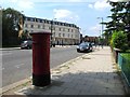
3
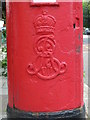
Edward VII postbox, Carlton Vale, NW6 - royal cipher
See Image
Image: © Mike Quinn
Taken: 4 Jul 2011
0.05 miles
4
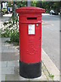
Edward VII postbox, Carlton Vale, NW6
Image: © Mike Quinn
Taken: 4 Jul 2011
0.05 miles
5
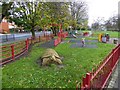
Play area, South Kilburn Open Space
The open space is a triangle of land to the south of Carlton Vale
Image: © David Smith
Taken: 26 Nov 2015
0.05 miles
6
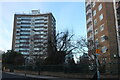
Housing estate on Carlton Vale, Kilburn
Image: © David Howard
Taken: 25 Jan 2021
0.05 miles
7
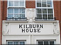
Detail above an entrance to Kilburn House, Malvern Place, NW6
See Image
Image: © Mike Quinn
Taken: 4 Jul 2011
0.07 miles
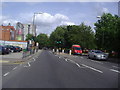
8
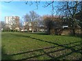
Recreation ground between Malvern Road and Carlton Vale
Image: © David Martin
Taken: 4 Mar 2013
0.07 miles
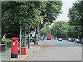
10
Carlton Vale, NW6 (2)
Shows the location of Image
Image: © Mike Quinn
Taken: 4 Jul 2011
0.08 miles